IMAGES TAKEN NEAR TO
Dolgwili Road, CARMARTHEN, SA31 2AE
Introduction
This page details the photographs taken nearby to Dolgwili Road, SA31 2AE by members of the Geograph project.
The Geograph project started in 2005 with the aim of publishing, organising and preserving representative images for every square kilometre of Great Britain, Ireland and the Isle of Man.

There are currently over 7.5m images from over14,400 individuals and you can help contribute to the project by visiting https://www.geograph.org.uk
Image Map
Images are licensed for reuse under creativecommons.org/licenses/by-sa/2.0
Notes
- Clicking on the map will re-center to the selected point.
- The higher the marker number, the further away the image location is from the centre of the postcode.
Image Listing (40 Images Found)
Images are licensed for reuse under creativecommons.org/licenses/by-sa/2.0
Image
Details
Distance
1
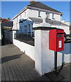
Queen Elizabeth II postbox, Dolgwili Road, Carmarthen
Alongside the A4243 Dolgwili Road opposite Glangwili General Hospital. https://www.geograph.org.uk/photo/6323694
Image: © Jaggery
Taken: 18 Nov 2019
0.01 miles
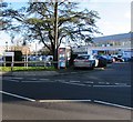
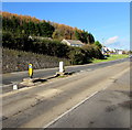
2

Zebra crossing, Dolgwili Road, Carmarthen
Six stripe crossing on the A4243 Dolgwili Road.
Image: © Jaggery
Taken: 18 Nov 2019
0.01 miles
3
BT phonebox, Dolgwili Road, Carmarthen
At the edge of Glangwili General Hospital.
Image: © Jaggery
Taken: 18 Nov 2019
0.02 miles
4
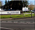
Bilingual hospital name sign, Carmarthen
Viewed across the A4243 Dolgwili Road in November 2019. A letter y is missing
from Ysbyty Cyffredinol Glangwili, Welsh for Glangwili General Hospital.
Image: © Jaggery
Taken: 18 Nov 2019
0.03 miles
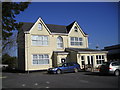
6
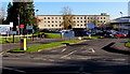
Main entrance to Glangwili General Hospital, Carmarthen
From Dolgwili Road.
Image: © Jaggery
Taken: 18 Nov 2019
0.05 miles
7
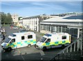
West Wales General Hospital, Glangwili, Carmarthen
Image: © Nigel Davies
Taken: 20 Jun 2005
0.06 miles
8
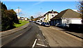
NNE along the A484 Bronwydd Road, Carmarthen
Viewed from this https://www.geograph.org.uk/photo/6323751 pedestrian refuge. This way for the Gwili Steam Railway.
Image: © Jaggery
Taken: 18 Nov 2019
0.06 miles
9
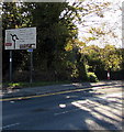
Dolgwili Road directions sign, Carmarthen
Alongside the A4243 Dolgwili Road on the approach to the roundabout https://www.geograph.org.uk/photo/6323995 at the A484 junction.
Image: © Jaggery
Taken: 18 Nov 2019
0.06 miles
10
Pedestrian refuge, Bronwydd Road, Carmarthen
Between Keep Left signs in the middle of the A484 Bronwydd Road.
Image: © Jaggery
Taken: 18 Nov 2019
0.09 miles