IMAGES TAKEN NEAR TO
Ffynnonddrain, CARMARTHEN, SA31 1TY
Introduction
This page details the photographs taken nearby to SA31 1TY by members of the Geograph project.
The Geograph project started in 2005 with the aim of publishing, organising and preserving representative images for every square kilometre of Great Britain, Ireland and the Isle of Man.

There are currently over 7.5m images from over14,400 individuals and you can help contribute to the project by visiting https://www.geograph.org.uk
Image Map (Loading...)


Getting Data...Please wait
Leaflet Map data © OpenStreetMap
Images are licensed for reuse under creativecommons.org/licenses/by-sa/2.0
Notes
- Clicking on the map will re-center to the selected point.
- The higher the marker number, the further away the image location is from the centre of the postcode.
Image Listing (8 Images Found)
Images are licensed for reuse under creativecommons.org/licenses/by-sa/2.0
Image
Details
Distance
1

Elim chapel
Chapel and cruciform topiary at Ffynnon Drain.
Image: © Alan Hughes
Taken: 27 Feb 2020
0.06 miles
2
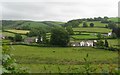
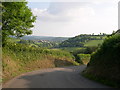
Valley with houses south of Ffynnon-ddrain
Image: © Colin Bell
Taken: 18 Jun 2008
0.08 miles
3
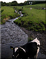
Cows graze the banks of Tawelan Brook
Below Ffynnon-ddrain bridge.
Image: © John Duckfield
Taken: 10 Sep 2009
0.09 miles
4
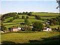
Elim Chapel and Brodirion Ffynnon-ddrain.
From Castell Howell hill.
Image: © John Duckfield
Taken: 10 Sep 2009
0.10 miles
5

Ffynnon Drain
Signpost at the entrance to Ffynnon Drain.
Image: © Alan Hughes
Taken: 27 Feb 2020
0.13 miles
6
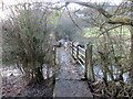
Pontdroed yn rhychwantu nant / A footbridge spanning a stream
Pontdroed yn rhychwantu Nant Tawelan.
A footbridge spans Tawelan Brook.
Image: © Alan Richards
Taken: 12 Jan 2023
0.14 miles
8
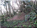
Llwybr coedog / Wooded path
Llwybr cyhoeddus yn mynd drwy goedwig ar lethrau Bryn Trefechan.
A public footpath heading through woods on the slopes of Trevaughan Hill.
Image: © Alan Richards
Taken: 12 Jan 2023
0.24 miles