IMAGES TAKEN NEAR TO
The Esplanade, CARMARTHEN, SA31 1NJ
Introduction
This page details the photographs taken nearby to The Esplanade, SA31 1NJ by members of the Geograph project.
The Geograph project started in 2005 with the aim of publishing, organising and preserving representative images for every square kilometre of Great Britain, Ireland and the Isle of Man.

There are currently over 7.5m images from over14,400 individuals and you can help contribute to the project by visiting https://www.geograph.org.uk
Image Map
Images are licensed for reuse under creativecommons.org/licenses/by-sa/2.0
Notes
- Clicking on the map will re-center to the selected point.
- The higher the marker number, the further away the image location is from the centre of the postcode.
Image Listing (117 Images Found)
Images are licensed for reuse under creativecommons.org/licenses/by-sa/2.0
Image
Details
Distance
1
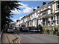
The Esplanade Carmarthen
Views of the Towy valley to the front.
Image: © John Duckfield
Taken: 13 Aug 2009
0.03 miles
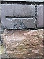
2
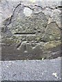
Ordnance Survey Cut Mark
This OS cut mark can be found on the wall to the SW side of Old Priory Road. It marks a point 11.076m above mean sea level.
Image: © Adrian Dust
Taken: 25 Jan 2014
0.04 miles
3
Ordnance Survey Cut Mark
This OS cut mark can be found to the NE of Penuel Street at the junction with lane. It marks a point 19.129m above mean sea level.
Image: © Adrian Dust
Taken: 25 Jan 2014
0.06 miles
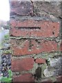
4
Ordnance Survey Cut Mark
This OS cut mark can be found on the wall next to the footpath gate on Old Priory Road. It marks a point 14.356m above mean sea level.
Image: © Adrian Dust
Taken: 25 Jan 2014
0.07 miles
5
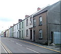
Priory Street houses, Carmarthen
Looking towards Abbey Mead, along the A484 from near the corner of Old Priory Road.
Image: © Jaggery
Taken: 30 May 2011
0.07 miles
6
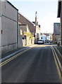
Penuel Street, Carmarthen
From the A484 Priory Street along Penuel Street towards Esplanade.
Image: © Jaggery
Taken: 18 Nov 2019
0.08 miles
7
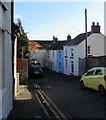
Old Priory Road, Carmarthen
Looking to the southeast from the corner of the A484 Priory Street.
Image: © Jaggery
Taken: 18 Nov 2019
0.08 miles
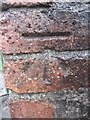
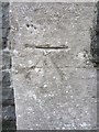
8
Ordnance Survey Cut Mark
This damaged OS cut mark can be found on the Vestry of Penuel Chapel on Penuel Street. It marks a point 22.970m above mean sea level.
Image: © Adrian Dust
Taken: 25 Jan 2014
0.09 miles
9
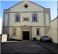
Grade II Listed Penuel Baptist Chapel, Carmarthen
Set back several metres from Priory Street.
The chapel was built in 1910 on the site of the original chapel of 1786.
Image: © Jaggery
Taken: 18 Nov 2019
0.09 miles
10
Ordnance Survey Cut Mark
This OS cut mark can be found on the Priory Congregational Chapel. It marks a point 21.420m above mean sea level.
Image: © Adrian Dust
Taken: 25 Jan 2014
0.10 miles