IMAGES TAKEN NEAR TO
Priory Street, CARMARTHEN, SA31 1NF
Introduction
This page details the photographs taken nearby to Priory Street, SA31 1NF by members of the Geograph project.
The Geograph project started in 2005 with the aim of publishing, organising and preserving representative images for every square kilometre of Great Britain, Ireland and the Isle of Man.

There are currently over 7.5m images from over14,400 individuals and you can help contribute to the project by visiting https://www.geograph.org.uk
Image Map
Images are licensed for reuse under creativecommons.org/licenses/by-sa/2.0
Notes
- Clicking on the map will re-center to the selected point.
- The higher the marker number, the further away the image location is from the centre of the postcode.
Image Listing (146 Images Found)
Images are licensed for reuse under creativecommons.org/licenses/by-sa/2.0
Image
Details
Distance
1
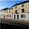
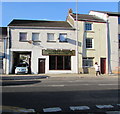
Tiny Tearaways in Carmarthen
Children's day nursery at 103 Priory Street.
Image: © Jaggery
Taken: 18 Nov 2019
0.02 miles
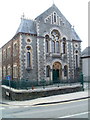
2
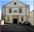
Grade II Listed Penuel Baptist Chapel, Carmarthen
Set back several metres from Priory Street.
The chapel was built in 1910 on the site of the original chapel of 1786.
Image: © Jaggery
Taken: 18 Nov 2019
0.02 miles
3
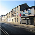
Former Priory Newsagents, Carmarthen
Shuttered former newsagents viewed across the A484 Priory Street in November 2019.
Image: © Jaggery
Taken: 18 Nov 2019
0.02 miles
4

Red arrow on a bilingual Penuel Baptist Chapel notice, Carmarthen
On railings on the Priory Street side of the chapel https://www.geograph.org.uk/photo/6330892 in November 2019.
Sunday services are being held in the vestry. The text is also in Welsh.
Image: © Jaggery
Taken: 18 Nov 2019
0.02 miles
5
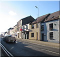
Y Dderwen Fach guesthouse, Carmarthen
Bed & breakfast accommodation on the right at 98 Priory Street.
Image: © Jaggery
Taken: 18 Nov 2019
0.03 miles
6
Carmarthen Tandoori Indian Takeaway
At 119 Priory Street viewed from Penuel Street in November 2019.
An August 2018 Google Street View shows Dhaka Indian & Bangladeshi Restaurant here.
Image: © Jaggery
Taken: 18 Nov 2019
0.04 miles
7
Priory Congregational Church, Carmarthen
Located on the corner of Priory Street and Old Priory Road.
http://www.geograph.org.uk/photo/2435122 to a closeup of the ornate doorway.
Image: © Jaggery
Taken: 30 May 2011
0.04 miles
8
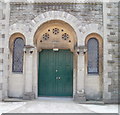
Ornate entrance doorway, Priory Congregational Church, Carmarthen
The church http://www.geograph.org.uk/photo/2435119 doorway faces Priory Street
Image: © Jaggery
Taken: 30 May 2011
0.04 miles
9
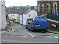
Old Priory Road passes through a house, Carmarthen
Viewed from Priory Street. Old Priory Road passes under an archway in a house, which thereby has a much reduced ground floor area!
The far end of Old Priory Road meets The Esplanade at the edge of the A40.
Image: © Jaggery
Taken: 30 May 2011
0.04 miles
10
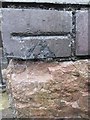
Ordnance Survey Cut Mark
This damaged OS cut mark can be found on the Vestry of Penuel Chapel on Penuel Street. It marks a point 22.970m above mean sea level.
Image: © Adrian Dust
Taken: 25 Jan 2014
0.04 miles