1
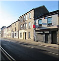
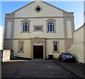
Former Priory Newsagents, Carmarthen
Shuttered former newsagents viewed across the A484 Priory Street in November 2019.
Image: © Jaggery
Taken: 18 Nov 2019
0.01 miles
2
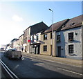
Y Dderwen Fach guesthouse, Carmarthen
Bed & breakfast accommodation on the right at 98 Priory Street.
Image: © Jaggery
Taken: 18 Nov 2019
0.02 miles
3
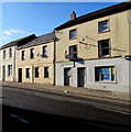
Tiny Tearaways in Carmarthen
Children's day nursery at 103 Priory Street.
Image: © Jaggery
Taken: 18 Nov 2019
0.02 miles
4
Priory Congregational Church, Carmarthen
Located on the corner of Priory Street and Old Priory Road.
http://www.geograph.org.uk/photo/2435122 to a closeup of the ornate doorway.
Image: © Jaggery
Taken: 30 May 2011
0.03 miles
5
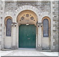
Ornate entrance doorway, Priory Congregational Church, Carmarthen
The church http://www.geograph.org.uk/photo/2435119 doorway faces Priory Street
Image: © Jaggery
Taken: 30 May 2011
0.03 miles
6
Old Priory Road passes through a house, Carmarthen
Viewed from Priory Street. Old Priory Road passes under an archway in a house, which thereby has a much reduced ground floor area!
The far end of Old Priory Road meets The Esplanade at the edge of the A40.
Image: © Jaggery
Taken: 30 May 2011
0.03 miles
7
Queen Elizabeth II postbox and Royal Mail drop box, Old Oak Lane, Carmarthen
Located here. https://www.geograph.org.uk/photo/6330851
Image: © Jaggery
Taken: 18 Nov 2019
0.03 miles
8
Grade II Listed Penuel Baptist Chapel, Carmarthen
Set back several metres from Priory Street.
The chapel was built in 1910 on the site of the original chapel of 1786.
Image: © Jaggery
Taken: 18 Nov 2019
0.03 miles
9
A484 Priory Street mini-roundabout, Carmarthen
At the Old Oak Lane junction.
Image: © Jaggery
Taken: 18 Nov 2019
0.03 miles
10
Red arrow on a bilingual Penuel Baptist Chapel notice, Carmarthen
On railings on the Priory Street side of the chapel https://www.geograph.org.uk/photo/6330892 in November 2019.
Sunday services are being held in the vestry. The text is also in Welsh.
Image: © Jaggery
Taken: 18 Nov 2019
0.03 miles


