IMAGES TAKEN NEAR TO
The Parade, CARMARTHEN, SA31 1LZ
Introduction
This page details the photographs taken nearby to The Parade, SA31 1LZ by members of the Geograph project.
The Geograph project started in 2005 with the aim of publishing, organising and preserving representative images for every square kilometre of Great Britain, Ireland and the Isle of Man.

There are currently over 7.5m images from over14,400 individuals and you can help contribute to the project by visiting https://www.geograph.org.uk
Image Map
Images are licensed for reuse under creativecommons.org/licenses/by-sa/2.0
Notes
- Clicking on the map will re-center to the selected point.
- The higher the marker number, the further away the image location is from the centre of the postcode.
Image Listing (160 Images Found)
Images are licensed for reuse under creativecommons.org/licenses/by-sa/2.0
Image
Details
Distance
1
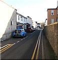
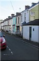
North Parade, Carmarthen
One-way street from the A484 Priory Street to The Parade.
Image: © Jaggery
Taken: 18 Nov 2019
0.01 miles
2
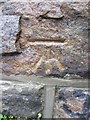
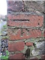
Ordnance Survey Cut Mark
This OS cut mark can be found on the wall of Dyffren House at the road junction. It marks a point 17.779m above mean sea level.
Image: © Adrian Dust
Taken: 25 Jan 2014
0.02 miles
3
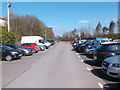
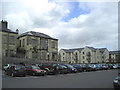
Car park on the site of Carmarthen railway goods yard
When the Carmarthen and Cardigan Railway first opened in October 1859 it ran from Myrtle Hill as far as the tin works. The station was on the opposite side of the river to today's station and the goods yard and other facilities were between the station and the tin works. The site is now a carpark.
Image: © Simon Parsons
Taken: 24 Mar 2017
0.02 miles
4
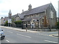
St John's church, Carmarthen
Church in Wales church on the corner of Priory Street and The Avenue.
Image: © Jaggery
Taken: 30 May 2011
0.05 miles
5
Row of houses in The Avenue, Carmarthen
From the A484 Priory Street, The Avenue leads to Esplanade and The Parade
Image: © Jaggery
Taken: 18 Nov 2019
0.05 miles
6
Priory Street Hospital
On the left can be seen the old Priory Street Hospital, a listed building, in a sorry state of disrepair. I understand that as part of the planning agreement permitting the developer to build the residential apartments on the right, he agreed to maintain the old hospital buildings. He does not seem to have done so and this is still a matter of controversy between him and the local authority.
Image: © Marion Phillips
Taken: 24 Apr 2008
0.05 miles
7
Ordnance Survey Cut Mark
This OS cut mark can be found to the NE of Penuel Street at the junction with lane. It marks a point 19.129m above mean sea level.
Image: © Adrian Dust
Taken: 25 Jan 2014
0.06 miles
8
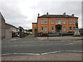
Carmarthenshire Infirmary
Carmarthenshire Infirmary was built in 1857-8 by William Wesley Jenkins of London. It was extended to the rear between 1899 and 1934, with most of these extensions being demolished in 2002. The abandoned and derelict main building was eventually renovated in 2015.
Ordnance Survey benchmark:
Context: Image
Close-up: Image
Image: © N Scott
Taken: 31 May 2023
0.06 miles
9
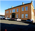
West side of Grade II Listed former Carmarthenshire Infirmary, Carmarthen
Set back from the east side of the A484 Priory Street. Cadw records that the foundation stone was laid on May 14th 1857. The infirmary which opened on July 1st 1858 was taken over by the National Health Service in 1948. The infirmary closed in the late 20th century.
Image: © Jaggery
Taken: 18 Nov 2019
0.07 miles
10
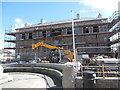
The former Carmarthen Infirmary, long derelict, now being redeveloped
Image: © John Lord
Taken: 8 Aug 2016
0.07 miles