IMAGES TAKEN NEAR TO
Capel Evan Road, CARMARTHEN, SA31 1EJ
Introduction
This page details the photographs taken nearby to Capel Evan Road, SA31 1EJ by members of the Geograph project.
The Geograph project started in 2005 with the aim of publishing, organising and preserving representative images for every square kilometre of Great Britain, Ireland and the Isle of Man.

There are currently over 7.5m images from over14,400 individuals and you can help contribute to the project by visiting https://www.geograph.org.uk
Image Map (Loading...)


Getting Data...Please wait
Leaflet Map data © OpenStreetMap
Images are licensed for reuse under creativecommons.org/licenses/by-sa/2.0
Notes
- Clicking on the map will re-center to the selected point.
- The higher the marker number, the further away the image location is from the centre of the postcode.
Image Listing (45 Images Found)
Images are licensed for reuse under creativecommons.org/licenses/by-sa/2.0
Image
Details
Distance
1
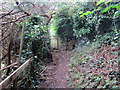
Llwybr i Gwmoernant / Path to Cwmoernant
Llwybr cyhoeddus yn arwain at dreflan Cwmoernant.
A public footpath heading towards the hamlet of Cwmoernant (trans. valley of the cold stream).
Image: © Alan Richards
Taken: 9 Oct 2019
0.12 miles
2
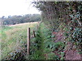
Llwybr i Gwmoernant / Path to Cwmoernant
Llwybr cyhoeddus yn arwain at dreflan Cwmoernant.
A public footpath approaching the hamlet of Cwmoernant (trans. valley of the cold stream).
Image: © Alan Richards
Taken: 9 Oct 2019
0.13 miles
3
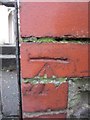
Ordnance Survey Cut Mark
This OS cut mark can be found on the gatepost of No6 Old Oak Lane. It marks a point 24.140m above mean sea level.
Image: © Adrian Dust
Taken: 25 Jan 2014
0.14 miles
4
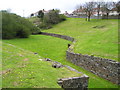
Amphitheatre Moridunum
Carmarthen was an important town in Roman times and the Romans built this amphitheatre for the purpose of holding gladiatorial shows and displays of wild beasts. Only part of the site is visible here because trees and bushes have been allowed to encroach on the far side. The local authority keeps the grass mown but does not provide any information for visitors.
Image: © Marion Phillips
Taken: 24 Apr 2008
0.16 miles
5

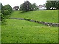
Old Oak Lane, Carmarthen
From the A484 Priory Street, Old Oak Lane leads to Richmond Terrace.
Image: © Jaggery
Taken: 18 Nov 2019
0.17 miles
6

Roman Amphitheatre, Carmarthen
Hidden in plain sight right next to Priory Street on the outskirts of town are the remains of a Roman amphitheatre.
Image: © Nigel Davies
Taken: 28 Jun 2005
0.18 miles
7
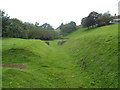
Remains of a Roman amphitheatre, Carmarthen
Excavated in 1968, this is one of only seven surviving Roman amphitheatres in the UK. It is located on the north side of the A484, here named Priory Street. The amphitheatre was part of Moridunum (Latin for sea fort), the ancient Roman fort and town in the Roman province of Britannia.
After the Roman era, Moridunum was known as Caerfyrddin. Fyrddin is a Welsh mutated form of Myrddin, which looks like a Welsh form of the Latin name. Caerfyrddin was later anglicised to Carmarthen. Caerfyrddin may have been misinterpreted as "Fort of Myrddin", hence the town's association with the Arthurian Merlin.
Image: © Jaggery
Taken: 12 Aug 2012
0.18 miles
8

Houses on the sunny side of the A484, Carmarthen
South facing houses on the approach to the Old Oak Lane junction.
Image: © Jaggery
Taken: 18 Nov 2019
0.18 miles
9
Roman amphitheatre, Carmarthen
Carmarthen's Roman amphitheatre was excavated in 1968 and 1970 and is an elliptical shape, approximately 90 metres by 60 metres. It is thought to date from around 75AD. The town of Carmarthen was known as 'Moridunum' by the Romans. It is one of two such visible amphitheatres in Wales, the other is at Caerleon.
Image: © Philip Halling
Taken: 16 Jun 2021
0.19 miles
10

The location of Merlyn's Tree
Carmarthen has many Merlyn based myths associated with it including (wrongly) the source of the town's name. On this corner, a tree once stood, over which Merlyn prophesied that:
When Merlyn's tree shall tumble down
Then shall fall Carmarthen town
... which is a pretty clever thing for the old wizard to have done really as the tree has since been dated to the 16th century, long after the days of King Arthur. Since then, locals have believed the town would flood if the tree ever fell.
In the early 19th century a local poisoned and killed the tree, but its dead limbs still stood here until 1978 when the council took it down (fearing it about to collapse) and kept parts of it standing in the Civic Hall, where they are to this day.
For some reason, the tree has been replaced by what can only be described as an overgrown sapling in an overgrown pot!
Image: © Hywel Williams
Taken: 1 Jun 2007
0.19 miles