IMAGES TAKEN NEAR TO
Harlech Crescent, SWANSEA, SA2 9LJ
Introduction
This page details the photographs taken nearby to Harlech Crescent, SA2 9LJ by members of the Geograph project.
The Geograph project started in 2005 with the aim of publishing, organising and preserving representative images for every square kilometre of Great Britain, Ireland and the Isle of Man.

There are currently over 7.5m images from over14,400 individuals and you can help contribute to the project by visiting https://www.geograph.org.uk
Image Map (Loading...)


Getting Data...Please wait
Leaflet Map data © OpenStreetMap
Images are licensed for reuse under creativecommons.org/licenses/by-sa/2.0
Notes
- Clicking on the map will re-center to the selected point.
- The higher the marker number, the further away the image location is from the centre of the postcode.
Image Listing (5 Images Found)
Images are licensed for reuse under creativecommons.org/licenses/by-sa/2.0
Image
Details
Distance
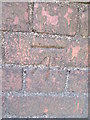
1

Ordnance Survey Cut Mark
This OS cut mark can be found on the wall of No57 Hendre Foilan Road. It marks a point 113.224m above mean sea level.
Image: © Adrian Dust
Taken: 28 Jan 2021
0.06 miles
3
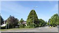
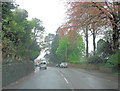
Junction of Park Way with Gower Road, Olchfa
Mature trees in this suburban setting
Image: © David Smith
Taken: 3 Jun 2018
0.22 miles
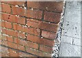
4
Ordnance Survey Cut Mark
This OS cut mark can be found on the south parapet of the bridge over the stream on Gower Road. It marks a point 77.843m above mean sea level.
Image: © Adrian Dust
Taken: 17 Jul 2014
0.25 miles
5
Ordnance Survey Cut Mark
This OS cut mark can be found on No82 Park Way. It marks a point 88.154m above mean sea level.
Image: © Adrian Dust
Taken: 28 Jan 2021
0.25 miles