IMAGES TAKEN NEAR TO
Carnglas Avenue, SWANSEA, SA2 9JQ
Introduction
This page details the photographs taken nearby to Carnglas Avenue, SA2 9JQ by members of the Geograph project.
The Geograph project started in 2005 with the aim of publishing, organising and preserving representative images for every square kilometre of Great Britain, Ireland and the Isle of Man.

There are currently over 7.5m images from over14,400 individuals and you can help contribute to the project by visiting https://www.geograph.org.uk
Image Map
Images are licensed for reuse under creativecommons.org/licenses/by-sa/2.0
Notes
- Clicking on the map will re-center to the selected point.
- The higher the marker number, the further away the image location is from the centre of the postcode.
Image Listing (11 Images Found)
Images are licensed for reuse under creativecommons.org/licenses/by-sa/2.0
Image
Details
Distance
1
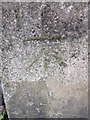
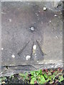
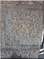
Ordnance Survey Cut Mark
This OS cut mark can be found on the remains of the gatepost leading to Bethel Chapel on the east side of Carnglas Road. It marks a point 97.792m above mean sea level.
Image: © Adrian Dust
Taken: 17 Jul 2014
0.05 miles
2
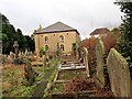
Capel Bethel Newydd / New Bethel Chapel
Capel Bethel Newydd, addoldy'r Annibynnwyr yn Sgeti. Adeiladwyd y capel cyntaf yn 1770 ac fe'i hailadeiladwyd yn 1842. Mae'r capel presennol yn dyddio o 1870.
New Bethel Welsh Independent Chapel in Sketty < Ynys Ceti (trans. Ceti's river meadow). The first chapel was built in 1770 and was later rebuilt in 1840. The present edifice dates from 1870.
Image: © Alan Richards
Taken: 13 Jan 2015
0.07 miles
3

Bethel Chapel, Tycoch
A Welsh Independent Non-Conformist chapel.
Image: © Deborah Tilley
Taken: 18 Jun 2016
0.07 miles
5
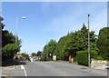
A4118 Gower Road approaches junction with Carnglas Road
Image: © Stuart Logan
Taken: 23 Apr 2014
0.09 miles
6
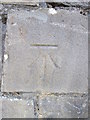
Ordnance Survey Rivet
This OS rivet can be found on the old school wall to the east of Carnglas Road. It marks a point 104.723m above mean sea level.
Image: © Adrian Dust
Taken: 17 Jul 2014
0.10 miles
7
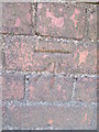
Ordnance Survey Cut Mark
This OS cut mark can be found on the wall at the junction of Gower Road & Sketty Park Road. It marks a point 84.442m above mean sea level.
Image: © Adrian Dust
Taken: 17 Jul 2014
0.11 miles
8
Ordnance Survey Cut Mark
This OS cut mark can be found on the south parapet of the bridge over the stream on Gower Road. It marks a point 77.843m above mean sea level.
Image: © Adrian Dust
Taken: 17 Jul 2014
0.14 miles
9
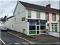
74 Tycoch Road
Shop with residential flat on the corner of Tycoch Road and Lon Masarn.
Image: © Alan Hughes
Taken: 14 Aug 2017
0.16 miles
10
Ordnance Survey Cut Mark
This OS cut mark can be found on the gatepost in front of Sketty Police Station, Gower Road. It marks a point 78.026m above mean sea level.
Image: © Adrian Dust
Taken: 17 Jul 2014
0.19 miles