IMAGES TAKEN NEAR TO
Llwyn Rhedyn, SWANSEA, SA2 9GU
Introduction
This page details the photographs taken nearby to Llwyn Rhedyn, SA2 9GU by members of the Geograph project.
The Geograph project started in 2005 with the aim of publishing, organising and preserving representative images for every square kilometre of Great Britain, Ireland and the Isle of Man.

There are currently over 7.5m images from over14,400 individuals and you can help contribute to the project by visiting https://www.geograph.org.uk
Image Map (Loading...)


Getting Data...Please wait
Leaflet Map data © OpenStreetMap
Images are licensed for reuse under creativecommons.org/licenses/by-sa/2.0
Notes
- Clicking on the map will re-center to the selected point.
- The higher the marker number, the further away the image location is from the centre of the postcode.
Image Listing (4 Images Found)
Images are licensed for reuse under creativecommons.org/licenses/by-sa/2.0
Image
Details
Distance
1
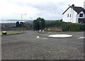
Mini roundabout
Mini roundabout at Llwynmawr Road and Rowan Avenue. Mumbles head visible in the distance.
Image: © Alan Hughes
Taken: 14 Aug 2017
0.06 miles
2
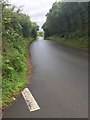
Llwynmawr Road
A country lane leading from the top of Carnglas into the countryside and Waunarlwydd to the north of Swansea.
Image: © Alan Hughes
Taken: 14 Aug 2017
0.21 miles
4
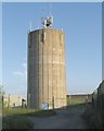
Water Tower near Cefn Coed
West of Cefn Coed, on the high point of the hill is a covered reservoir accompanied by this water tower. Like the tower of the nearby Cefn Coed hospital it is prominent on the skyline and can be seen from within Swansea to the south and for several miles outside Swansea to the north as well.
Image: © Nigel Davies
Taken: 18 Jun 2005
0.23 miles