IMAGES TAKEN NEAR TO
Coniston Walk, SWANSEA, SA2 9FD
Introduction
This page details the photographs taken nearby to Coniston Walk, SA2 9FD by members of the Geograph project.
The Geograph project started in 2005 with the aim of publishing, organising and preserving representative images for every square kilometre of Great Britain, Ireland and the Isle of Man.

There are currently over 7.5m images from over14,400 individuals and you can help contribute to the project by visiting https://www.geograph.org.uk
Image Map
Images are licensed for reuse under creativecommons.org/licenses/by-sa/2.0
Notes
- Clicking on the map will re-center to the selected point.
- The higher the marker number, the further away the image location is from the centre of the postcode.
Image Listing (16 Images Found)
Images are licensed for reuse under creativecommons.org/licenses/by-sa/2.0
Image
Details
Distance
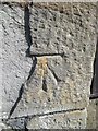
1
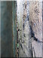
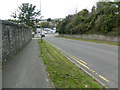
Ordnance Survey Cut Mark
This OS cut mark is behind a green metal box which stands in front of a wall to the south of Ty-Coch Road. You can just make it out if you look from above (as in the photo) or from the left side. It marks a point 92.863m above mean sea level.
Image: © Adrian Dust
Taken: 17 Jul 2014
0.07 miles
2
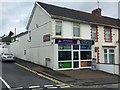
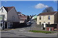
74 Tycoch Road
Shop with residential flat on the corner of Tycoch Road and Lon Masarn.
Image: © Alan Hughes
Taken: 14 Aug 2017
0.13 miles
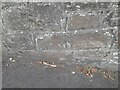
3
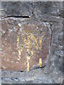
Ordnance Survey Cut Mark
This OS cut mark can be found on the wall to the NE of the road junction. It marks a point 89.739m above mean sea level.
Image: © Adrian Dust
Taken: 17 Jul 2014
0.15 miles
4
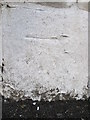
Ordnance Survey Cut Mark
This OS cut mark can be found on the wall of No84 Vivian Street. It marks a point 78.919m above mean sea level.
Image: © Adrian Dust
Taken: 17 Jul 2014
0.15 miles
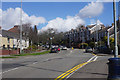
5
Glanmor Rd, approaching the junction with Vivian Rd, Swansea
Image: © John Lord
Taken: 6 Oct 2017
0.16 miles
6
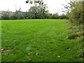
Grasses area near the junction of Glanmor Rd and Sketty Ave, Swansea
Image: © John Lord
Taken: 6 Oct 2017
0.17 miles
7
Ordnance Survey Cut Mark
This OS cut mark can be found on the SE side of Townhill Road. It marks a point 47.040m above mean sea level.
Image: © Adrian Dust
Taken: 19 Sep 2022
0.18 miles
8
Vivian Road, Sketty
Part of the A4216, which is the only major route to the Gower which doesn't go through the middle of Swansea. The land here continues to rise away from the coast.
Image: © Bill Boaden
Taken: 5 Apr 2016
0.18 miles
9
Kimberley Road
A residential side road in Sketty.
Image: © Bill Boaden
Taken: 5 Apr 2016
0.18 miles
10
Ordnance Survey Cut Mark
This OS cut mark can be found on the wall of No2 Kimberley Road. It marks a point 70.226m above mean sea level.
Image: © Adrian Dust
Taken: 17 Jul 2014
0.19 miles