IMAGES TAKEN NEAR TO
Gower Road, SWANSEA, SA2 9FB
Introduction
This page details the photographs taken nearby to Gower Road, SA2 9FB by members of the Geograph project.
The Geograph project started in 2005 with the aim of publishing, organising and preserving representative images for every square kilometre of Great Britain, Ireland and the Isle of Man.

There are currently over 7.5m images from over14,400 individuals and you can help contribute to the project by visiting https://www.geograph.org.uk
Image Map (Loading...)


Getting Data...Please wait
Leaflet Map data © OpenStreetMap
Images are licensed for reuse under creativecommons.org/licenses/by-sa/2.0
Notes
- Clicking on the map will re-center to the selected point.
- The higher the marker number, the further away the image location is from the centre of the postcode.
Image Listing (30 Images Found)
Images are licensed for reuse under creativecommons.org/licenses/by-sa/2.0
Image
Details
Distance
1
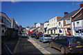
Gower Road, Sketty
Still a focus for shops.
Image: © Bill Boaden
Taken: 5 Apr 2016
0.03 miles
2

Shell filling station, Gower Road, Sketty
Image: © David Smith
Taken: 3 Jun 2018
0.04 miles
3
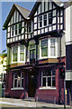
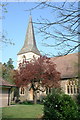
The Bush Inn, Sketty
The Bush was across the road from the Vivian Arms, which was always more favoured by the students. The Bush was more of a local, the bell-ringers from St.Paul's Sketty, would go there on practice night. Just to the right was the International Stores.
Image: © Brian Whittle
Taken: 6 May 1979
0.05 miles
4
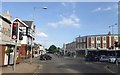
Crossroads in the centre of Sketty
Looking across Vivian Road from Gower Road
Image: © David Smith
Taken: 3 Jun 2018
0.06 miles
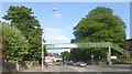
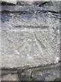
6
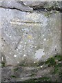
Ordnance Survey Cut Mark
This OS cut mark can be found on the wall to the west of the entrance of St Paul's Church. It marks a point 57.360m above mean sea level.
Image: © Adrian Dust
Taken: 7 Feb 2014
0.08 miles
10
Ordnance Survey Cut Mark
This OS cut mark can be found on the wall to the SE of De La Beche Road. It marks a point 61.353m above mean sea level.
Image: © Adrian Dust
Taken: 7 Feb 2014
0.09 miles