IMAGES TAKEN NEAR TO
Parklands View, SWANSEA, SA2 8LT
Introduction
This page details the photographs taken nearby to Parklands View, SA2 8LT by members of the Geograph project.
The Geograph project started in 2005 with the aim of publishing, organising and preserving representative images for every square kilometre of Great Britain, Ireland and the Isle of Man.

There are currently over 7.5m images from over14,400 individuals and you can help contribute to the project by visiting https://www.geograph.org.uk
Image Map (Loading...)


Getting Data...Please wait
Leaflet Map data © OpenStreetMap
Images are licensed for reuse under creativecommons.org/licenses/by-sa/2.0
Notes
- Clicking on the map will re-center to the selected point.
- The higher the marker number, the further away the image location is from the centre of the postcode.
Image Listing (7 Images Found)
Images are licensed for reuse under creativecommons.org/licenses/by-sa/2.0
Image
Details
Distance
1
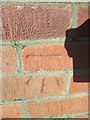
Ordnance Survey Cut Mark
This OS cut mark can be found on No84 Sketty Park Drive. It marks a point 63.837m above mean sea level.
Image: © Adrian Dust
Taken: 9 Feb 2016
0.10 miles
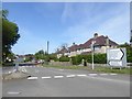
2
Road junction
Junction of Rhydian-y-Defaid Drive and Derwen Fawr Road.
Image: © Alan Hughes
Taken: 14 Aug 2017
0.15 miles
3

Ordnance Survey Cut Mark
This OS cut mark can be found on No128 Sketty Park Drive. It marks a point 71.146m above mean sea level.
Image: © Adrian Dust
Taken: 9 Feb 2016
0.18 miles
4
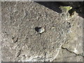
Ordnance Survey Rivet
This OS rivet can be found on the entrance step of No22 Rhyd Y Defaid Drive. It marks a point 52.883m above mean sea level.
Image: © Adrian Dust
Taken: 7 Feb 2014
0.18 miles
5
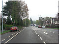
Derwen Fawr Road, B4436, Sketty, Swansea
A wide residential road with spacious houses and gardens
Image: © David Smith
Taken: 3 Jun 2018
0.18 miles
6
Sketty Park Road approaches junction with A4216
Image: © Stuart Logan
Taken: 23 Apr 2014
0.23 miles
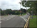
7
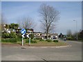
Roundabout
The Spinning Wheel public house can be seen behind the roundabout.
Image: © David Sharp
Taken: 5 Apr 2007
0.24 miles