IMAGES TAKEN NEAR TO
Y Deri, SWANSEA, SA2 8ET
Introduction
This page details the photographs taken nearby to Y Deri, SA2 8ET by members of the Geograph project.
The Geograph project started in 2005 with the aim of publishing, organising and preserving representative images for every square kilometre of Great Britain, Ireland and the Isle of Man.

There are currently over 7.5m images from over14,400 individuals and you can help contribute to the project by visiting https://www.geograph.org.uk
Image Map (Loading...)


Getting Data...Please wait
Leaflet Map data © OpenStreetMap
Images are licensed for reuse under creativecommons.org/licenses/by-sa/2.0
Notes
- Clicking on the map will re-center to the selected point.
- The higher the marker number, the further away the image location is from the centre of the postcode.
Image Listing (59 Images Found)
Images are licensed for reuse under creativecommons.org/licenses/by-sa/2.0
Image
Details
Distance
1
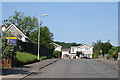
Swansea: Lower Sketty
Gwerneinon Road, looking west
Image: © Martin Bodman
Taken: 8 Jun 2006
0.06 miles
2
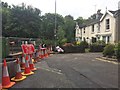
Road Closed
Roadworks at the end of Derwen Fawr Road.
Image: © Alan Hughes
Taken: 14 Aug 2017
0.07 miles
3
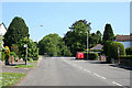
Swansea: Lower Sketty
Derwen Fawr Road, otherwise the B4436, looking north
Image: © Martin Bodman
Taken: 8 Jun 2006
0.08 miles
4
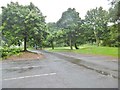
Lower Sketty, car park
Landscaped car park at Clyne Valley Country Park. http://www.swansea.gov.uk/clynevalleycountrypark
Image: © Mike Faherty
Taken: 15 Jul 2016
0.10 miles
5
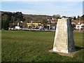
Halfway Petrol Station from the Trig Point
The Shell Halfway Petrol Station is so-named from its situation halfway round Swansea Bay between Swansea and The Mumbles. It is also the only filling station on that carriageway along a 6 mile stretch.
Image: © Robert Cuthill
Taken: 6 Jan 2009
0.11 miles
6
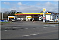
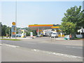
Shell filling station, shop and car wash, Lower Sketty, Swansea
Viewed across the A4067 Mumbles Road.
Image: © Jaggery
Taken: 26 Feb 2012
0.11 miles
7
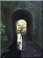
Victorian Tunnel
Built to allow the Cwm Stream and a footpath to pass under the former track-bed at Mumbles Road station of the Swansea to Shrewsbury LMS railway line. The stream has a confluence with the Clyne River close to the tree beyond the tunnel.
Image: © Robert Cuthill
Taken: 9 Feb 2006
0.12 miles
9
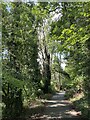
Clyne Valley lane
Leading from Black Pill to Killay.
Image: © Alan Hughes
Taken: 20 Sep 2022
0.14 miles
10
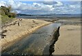
Dog walkers on Swansea beach at Blackpill
The Clyne River is in the foreground.
Image: © john bristow
Taken: 23 Oct 2020
0.14 miles