IMAGES TAKEN NEAR TO
Ocean View Close, SWANSEA, SA2 8EP
Introduction
This page details the photographs taken nearby to Ocean View Close, SA2 8EP by members of the Geograph project.
The Geograph project started in 2005 with the aim of publishing, organising and preserving representative images for every square kilometre of Great Britain, Ireland and the Isle of Man.

There are currently over 7.5m images from over14,400 individuals and you can help contribute to the project by visiting https://www.geograph.org.uk
Image Map (Loading...)


Getting Data...Please wait
Leaflet Map data © OpenStreetMap
Images are licensed for reuse under creativecommons.org/licenses/by-sa/2.0
Notes
- Clicking on the map will re-center to the selected point.
- The higher the marker number, the further away the image location is from the centre of the postcode.
Image Listing (14 Images Found)
Images are licensed for reuse under creativecommons.org/licenses/by-sa/2.0
Image
Details
Distance
1
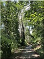
Clyne Valley lane
Leading from Black Pill to Killay.
Image: © Alan Hughes
Taken: 20 Sep 2022
0.10 miles
2
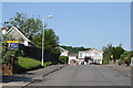
Swansea: Lower Sketty
Gwerneinon Road, looking west
Image: © Martin Bodman
Taken: 8 Jun 2006
0.12 miles
3
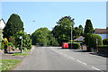
Swansea: Lower Sketty
Derwen Fawr Road, otherwise the B4436, looking north
Image: © Martin Bodman
Taken: 8 Jun 2006
0.13 miles
4
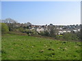
Where Town Meets Country
The Clyne Country Park butts up against Gwerneinon and Royal Oak Roads in Lower Sketty.
Image: © Robert Cuthill
Taken: 21 Apr 2005
0.14 miles

6
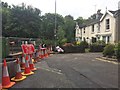
Road Closed
Roadworks at the end of Derwen Fawr Road.
Image: © Alan Hughes
Taken: 14 Aug 2017
0.17 miles
7
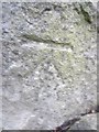
Ordnance Survey Cut Mark
This OS cut mark can be found on the wall of No56 Ashleigh Road. It marks a point 24.427m above mean sea level.
Image: © Adrian Dust
Taken: 7 Feb 2014
0.19 miles
8
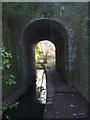
Victorian Tunnel
Built to allow the Cwm Stream and a footpath to pass under the former track-bed at Mumbles Road station of the Swansea to Shrewsbury LMS railway line. The stream has a confluence with the Clyne River close to the tree beyond the tunnel.
Image: © Robert Cuthill
Taken: 9 Feb 2006
0.22 miles
9
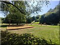
Clyne Valley park play area
This is a newly refurbished children's play area in the Clyne Valley park, Swansea.
Image: © Emma M Baker
Taken: 7 Jul 2023
0.22 miles
10
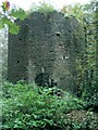
Ivy Tower in Clyne Valley Country Park
This tower is right beside the lane up to the lodge. There are 2 arched entrances, away from the lane. I couldn't see any other walls or gates.
I was always told it was a chimney from the old arsenic and copper works but the ground-level entrances and internal staircase never seemed to agree with this interpretation.
I have since found that this tower is part of Scheduled Ancient Monument GM475. The schedule document states that the chimney was "gothicised" in the late 19th Century to become a folly for Clyne Castle.
Image: © Nigel Davies
Taken: 22 Oct 2006
0.23 miles