IMAGES TAKEN NEAR TO
Saunders Way, SWANSEA, SA2 8AY
Introduction
This page details the photographs taken nearby to Saunders Way, SA2 8AY by members of the Geograph project.
The Geograph project started in 2005 with the aim of publishing, organising and preserving representative images for every square kilometre of Great Britain, Ireland and the Isle of Man.

There are currently over 7.5m images from over14,400 individuals and you can help contribute to the project by visiting https://www.geograph.org.uk
Image Map (Loading...)


Getting Data...Please wait
Leaflet Map data © OpenStreetMap
Images are licensed for reuse under creativecommons.org/licenses/by-sa/2.0
Notes
- Clicking on the map will re-center to the selected point.
- The higher the marker number, the further away the image location is from the centre of the postcode.
Image Listing (6 Images Found)
Images are licensed for reuse under creativecommons.org/licenses/by-sa/2.0
Image
Details
Distance
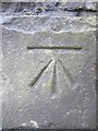
1
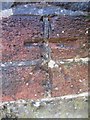
Ordnance Survey Cut Mark
This OS cut mark can be found on the wall of No101 Cherry Grove. It marks a point 36.991m above mean sea level.
Image: © Adrian Dust
Taken: 7 Feb 2014
0.04 miles
2
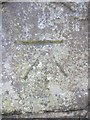
Ordnance Survey Cut Mark
This OS cut mark can be found on the wall at the junction of Derwen Fawr Road & Saunder's Way. It marks a point 31.190m above mean sea level.
Image: © Adrian Dust
Taken: 7 Feb 2014
0.08 miles
3
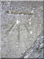
Ordnance Survey Cut Mark
This OS cut mark can be found on the wall of No70 Cherry Grove. It marks a point 39.164m above mean sea level.
Image: © Adrian Dust
Taken: 7 Feb 2014
0.13 miles
4
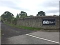
Bible College lane
Lane alongside the Bible College of Wales, Lower Sketty.
Image: © Alan Hughes
Taken: 14 Aug 2017
0.14 miles
5
Ordnance Survey Cut Mark
This OS cut mark can be found on the wall of the Bible College to the east of Derwen Fawr Road. It marks a point 26.207m above mean sea level.
Image: © Adrian Dust
Taken: 7 Feb 2014
0.17 miles
6
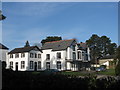
The Bible College of Wales
The main building of the Bible College of Wales, formerly a house named Derwen Fawr after which this area of Lower Sketty is named.
Image: © Robert Cuthill
Taken: 6 Jan 2009
0.19 miles