IMAGES TAKEN NEAR TO
Plas Newydd, SWANSEA, SA2 7UN
Introduction
This page details the photographs taken nearby to Plas Newydd, SA2 7UN by members of the Geograph project.
The Geograph project started in 2005 with the aim of publishing, organising and preserving representative images for every square kilometre of Great Britain, Ireland and the Isle of Man.

There are currently over 7.5m images from over14,400 individuals and you can help contribute to the project by visiting https://www.geograph.org.uk
Image Map
Images are licensed for reuse under creativecommons.org/licenses/by-sa/2.0
Notes
- Clicking on the map will re-center to the selected point.
- The higher the marker number, the further away the image location is from the centre of the postcode.
Image Listing (21 Images Found)
Images are licensed for reuse under creativecommons.org/licenses/by-sa/2.0
Image
Details
Distance
1
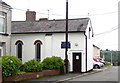
St. Martin's Church in Dunvant
This little church, which is a daughter church to St. Hilary's in Killay, was converted from a shop and was opened in 1949.
Image: © john bristow
Taken: 28 Jun 2013
0.07 miles
3
St Martin?s Church, Dunvant
A small church, seating only about 40 people, in Fairwood Road, Dunvant.
Image: © Alan Hughes
Taken: 15 May 2019
0.08 miles
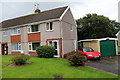
4
Terrace housing on Killan Road, Dunvant
Image: © john bristow
Taken: 28 Jun 2013
0.09 miles
5
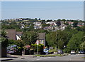
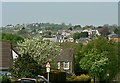
West Dunvant, from Dunvant Hill
The cars coming towards the camera have just climbed the 1 in 5 gradient from the centre of the village. Buildings in the village of Three Crosses can be seen on the skyline to the left of the picture.
Image: © john bristow
Taken: 24 Jul 2012
0.10 miles
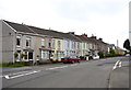
6
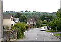
Fairwood Road in Dunvant
The buildings on the skyline are in Upper Killay
Image: © john bristow
Taken: 28 Jun 2013
0.11 miles
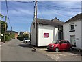
7
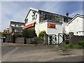
Dunvant Stores
Village store in Dunvant.
Image: © Alan Hughes
Taken: 15 May 2019
0.11 miles
8
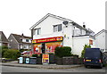
The village shop on Killan Road, Dunvant
Image: © john bristow
Taken: 28 Jun 2013
0.11 miles
9
West Dunvant
West Dunvant, from Dunvant Road. The village of Three Crosses is on the skyline.
Image: © john bristow
Taken: 24 Apr 2020
0.12 miles
10
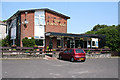
Dunvant: The Found Out
Public house. Looking north west
Image: © Martin Bodman
Taken: 8 Jun 2006
0.13 miles