IMAGES TAKEN NEAR TO
Goetre Fach Road, SWANSEA, SA2 7SQ
Introduction
This page details the photographs taken nearby to Goetre Fach Road, SA2 7SQ by members of the Geograph project.
The Geograph project started in 2005 with the aim of publishing, organising and preserving representative images for every square kilometre of Great Britain, Ireland and the Isle of Man.

There are currently over 7.5m images from over14,400 individuals and you can help contribute to the project by visiting https://www.geograph.org.uk
Image Map (Loading...)


Getting Data...Please wait
Leaflet Map data © OpenStreetMap
Images are licensed for reuse under creativecommons.org/licenses/by-sa/2.0
Notes
- Clicking on the map will re-center to the selected point.
- The higher the marker number, the further away the image location is from the centre of the postcode.
Image Listing (52 Images Found)
Images are licensed for reuse under creativecommons.org/licenses/by-sa/2.0
Image
Details
Distance
4
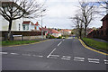
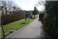
Wimmerfield Avenue, Killay
One of the more outlying suburban roads of Swansea.
Image: © Bill Boaden
Taken: 6 Apr 2016
0.11 miles
6
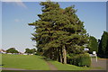
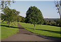
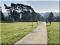
The northern entrance to Dunvant Park
Coming down the hill off Dunvant Road.
Image: © Bill Boaden
Taken: 6 Apr 2016
0.12 miles
7
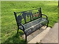
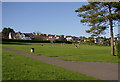
Seat in Dunvant Park commemorating the dead of the First World War
Image: © john bristow
Taken: 19 Apr 2023
0.12 miles
8
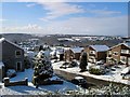
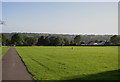
Killay Snow
View from Bron-y-bryn towards Hendrefoilan Road
Image: © Rachel Thomas
Taken: Unknown
0.14 miles
10
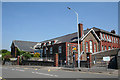
Dunvant: Dunvant Primary School
Looking north west. The school is administered by the City and County of Swansea
Image: © Martin Bodman
Taken: 8 Jun 2006
0.15 miles