IMAGES TAKEN NEAR TO
Maes Yr Efail, SWANSEA, SA2 7PY
Introduction
This page details the photographs taken nearby to Maes Yr Efail, SA2 7PY by members of the Geograph project.
The Geograph project started in 2005 with the aim of publishing, organising and preserving representative images for every square kilometre of Great Britain, Ireland and the Isle of Man.

There are currently over 7.5m images from over14,400 individuals and you can help contribute to the project by visiting https://www.geograph.org.uk
Image Map (Loading...)


Getting Data...Please wait
Leaflet Map data © OpenStreetMap
Images are licensed for reuse under creativecommons.org/licenses/by-sa/2.0
Notes
- Clicking on the map will re-center to the selected point.
- The higher the marker number, the further away the image location is from the centre of the postcode.
Image Listing (2 Images Found)
Images are licensed for reuse under creativecommons.org/licenses/by-sa/2.0
Image
Details
Distance
1
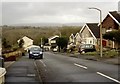
Bro Dirion, Dunvant
This road is part of the Penlan Farm estate, built in the 1960s.
Image: © john bristow
Taken: 3 Feb 2018
0.21 miles
2
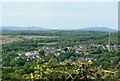
View over Gower
West Dunvant and Fairwood Common from above Killay.
Image: © john bristow
Taken: 12 May 2020
0.23 miles