IMAGES TAKEN NEAR TO
Dunvant Road, SWANSEA, SA2 7NL
Introduction
This page details the photographs taken nearby to Dunvant Road, SA2 7NL by members of the Geograph project.
The Geograph project started in 2005 with the aim of publishing, organising and preserving representative images for every square kilometre of Great Britain, Ireland and the Isle of Man.

There are currently over 7.5m images from over14,400 individuals and you can help contribute to the project by visiting https://www.geograph.org.uk
Image Map (Loading...)


Getting Data...Please wait
Leaflet Map data © OpenStreetMap
Images are licensed for reuse under creativecommons.org/licenses/by-sa/2.0
Notes
- Clicking on the map will re-center to the selected point.
- The higher the marker number, the further away the image location is from the centre of the postcode.
Image Listing (9 Images Found)
Images are licensed for reuse under creativecommons.org/licenses/by-sa/2.0
Image
Details
Distance
1

Pentref Myfyrwyr Hendrefoelan Student Village
Cerddwyr yn mynd drwy bentre myfyrwyr Hendrefoelan. Astudia'r myfyrwyr ym Mhrifysgol Abertawe.
Walkers at Hendrefoelan (trans. winter abode of the bare hill) student village. The students study at Swansea University.
Image: © Alan Richards
Taken: 10 Oct 2004
0.10 miles
2

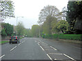
Ordnance Survey Cut Mark
This OS cut mark can be found on the Sub-Station SW side of Wimmerfield Drive. It marks a point 98.990m above mean sea level.
Image: © Adrian Dust
Taken: 28 Jan 2021
0.12 miles
3
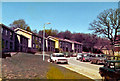
Hendrefoelan Student Village
Scanned from an old (cheap) colour photo, hence the washed out tints. The student village for Swansea University, the "newer" houses built in 1977 are seen on the left with the older houses just to the right.
All the buildings in this view have been demolished and replaced by a suburban estate of houses for sale.
Image: © Brian Whittle
Taken: 4 Jul 1979
0.13 miles
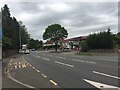
6
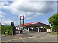
Texaco filling station, Gower Road, Killay
Image: © David Smith
Taken: 3 Jun 2018
0.20 miles
8
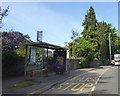
A4118 at Killay
Bus stop and petrol station on the A4118 at Killay.
Image: © Alan Hughes
Taken: 26 Jun 2019
0.20 miles
9

Ordnance Survey Cut Mark
This OS cut mark can be found on the wall south side of Gower Road. It marks a point 82.564m above mean sea level.
Image: © Adrian Dust
Taken: 28 Jan 2021
0.23 miles