IMAGES TAKEN NEAR TO
Fairwood, SWANSEA, SA2 7JX
Introduction
This page details the photographs taken nearby to SA2 7JX by members of the Geograph project.
The Geograph project started in 2005 with the aim of publishing, organising and preserving representative images for every square kilometre of Great Britain, Ireland and the Isle of Man.

There are currently over 7.5m images from over14,400 individuals and you can help contribute to the project by visiting https://www.geograph.org.uk
Image Map
Images are licensed for reuse under creativecommons.org/licenses/by-sa/2.0
Notes
- Clicking on the map will re-center to the selected point.
- The higher the marker number, the further away the image location is from the centre of the postcode.
Image Listing (4 Images Found)
Images are licensed for reuse under creativecommons.org/licenses/by-sa/2.0
Image
Details
Distance
1
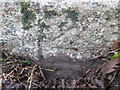
Ordnance Survey Cut Mark
This OS cut mark can be found on the granite gatepost which is on its side next to the gateway. It marked a point 84.448m above mean sea level.
Image: © Adrian Dust
Taken: 13 Dec 2015
0.11 miles
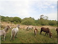
3
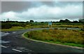
Approach to Swansea University Playing Fields
Road to playing fields leads off A4118 about a mile west of Upper Killay and north-east of Swansea Airport.
Image: © Clint Mann
Taken: 25 Aug 2014
0.21 miles
4
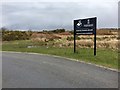
Fairwood Training Ground
Sign for the Swansea University training ground on Fairwood common.
Image: © Alan Hughes
Taken: 11 Mar 2019
0.22 miles