IMAGES TAKEN NEAR TO
Ellis Grove, SWANSEA, SA2 7HB
Introduction
This page details the photographs taken nearby to Ellis Grove, SA2 7HB by members of the Geograph project.
The Geograph project started in 2005 with the aim of publishing, organising and preserving representative images for every square kilometre of Great Britain, Ireland and the Isle of Man.

There are currently over 7.5m images from over14,400 individuals and you can help contribute to the project by visiting https://www.geograph.org.uk
Image Map
Images are licensed for reuse under creativecommons.org/licenses/by-sa/2.0
Notes
- Clicking on the map will re-center to the selected point.
- The higher the marker number, the further away the image location is from the centre of the postcode.
Image Listing (10 Images Found)
Images are licensed for reuse under creativecommons.org/licenses/by-sa/2.0
Image
Details
Distance
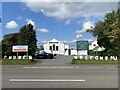
1
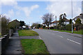
Gower Road, Upper Killay
Most of Upper Killay appears to be a residential extension from Swansea.
Image: © Bill Boaden
Taken: 6 Apr 2016
0.09 miles
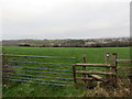
2
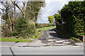
Track to Wern-fawr Farm
A little reminder of farming activity before the houses got here.
Image: © Bill Boaden
Taken: 6 Apr 2016
0.10 miles
3
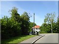
Telephone box, Upper Killay
At the junction of Gower Road and Hen Parc Lane
Image: © David Smith
Taken: 3 Jun 2018
0.13 miles
4
Upper Killay Pines Congregational Church
The Congregational chapel dates from 1911. The building also accommodates a Korean church.
Image: © Bill Boaden
Taken: 6 Apr 2016
0.14 miles
6
Llwybr Cila / Killay Footpath
Llwybr cyhoeddus yng Nghila Ucha gyda phentre Dyfnant yn y pellter.
A public footpath at Upper Killay < Cila Uchaf (trans. nooks) with the village of Dunvant < Dyfnant (trans. deep valley) in the distance.
Image: © Alan Richards
Taken: 5 Jan 2015
0.16 miles
7
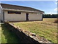
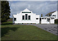
Recreational Hall
Upper Killay - recreational hall and rugby pitch.
Image: © Alan Hughes
Taken: 23 Jul 2018
0.18 miles
8
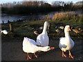
Duckpond just off Fairwood Lane
In the late 1980s a community conservation project was established to create a wildlife habitat encompassing the site of the former village pond. This project proved enormously successful and won a number of major national and international awards.
These rather vociferous residents who guard the pond now expect to be fed morsels of bread from every car that merely stops at this location.
The lake in the background is frozen over and had been so for a week or so.
Image: © Hywel Williams
Taken: 1 Jan 2010
0.21 miles
9
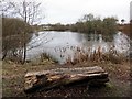
Pwll Mawr
Llyn yng Nghila Uchaf o'r enw Pwll Mawr.
A lake in Upper Killay < Cila Uchaf (trans. nooks) known as Pwll Mawr (trans. big pool).
Image: © Alan Richards
Taken: 5 Jan 2015
0.23 miles
10
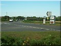
Road junction where B4271 meets A4118
Image: © Jennifer Luther Thomas
Taken: 22 Jul 2006
0.23 miles