IMAGES TAKEN NEAR TO
Heaseland Place, SWANSEA, SA2 7EQ
Introduction
This page details the photographs taken nearby to Heaseland Place, SA2 7EQ by members of the Geograph project.
The Geograph project started in 2005 with the aim of publishing, organising and preserving representative images for every square kilometre of Great Britain, Ireland and the Isle of Man.

There are currently over 7.5m images from over14,400 individuals and you can help contribute to the project by visiting https://www.geograph.org.uk
Image Map
Images are licensed for reuse under creativecommons.org/licenses/by-sa/2.0
Notes
- Clicking on the map will re-center to the selected point.
- The higher the marker number, the further away the image location is from the centre of the postcode.
Image Listing (13 Images Found)
Images are licensed for reuse under creativecommons.org/licenses/by-sa/2.0
Image
Details
Distance
1
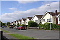
Broadmead, Dunvant
A lot of the dwellings on this road have beautiful views over open countryside.
Image: © john bristow
Taken: 8 Jun 2012
0.06 miles
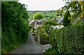
2
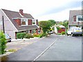
Y Glyn, Dunvant
1960s Wimpey semi-detached dormer bungalows. The far house on the left (number 7) is the first house I owned back in 1966.
Image: © Oliver Dixon
Taken: 21 Jun 2006
0.13 miles
3
Dunvant boundary sign at the northern edge of Killay, Swansea
Alongside the B4296 Goetre Fawr Road. Dunvant is a suburban district in the City and County of Swansea. The English name Dunvant shows a reversal of two consonants from the Welsh name Dyfnant.
Image: © Jaggery
Taken: 18 Sep 2014
0.15 miles
4
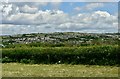
Dunvant and Killay
Dunvant and Killay, seen from Upper Killay
Image: © john bristow
Taken: 5 Jun 2020
0.16 miles
5
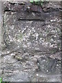
Ordnance Survey Cut Mark
This OS cut mark can be found on the wall of No224 Dunvant Road. It marks a point 93.674m above mean sea level.
Image: © Adrian Dust
Taken: 13 Dec 2015
0.17 miles
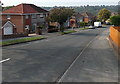
6
Derlwyn, Dunvant
Access to a large housing estate.
Image: © Bill Boaden
Taken: 6 Apr 2016
0.18 miles
7
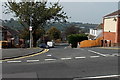
Broadmead, Killay, Swansea
Viewed from near the Goetre Fawr Road junction, looking along
Broadmead towards the turnings for Ash Grove and Kennington Close.
Image: © Jaggery
Taken: 18 Sep 2014
0.20 miles
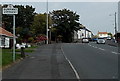
8
Llanerch Road, Dunvant
The housing on the horizon is in Upper Killay.
Image: © john bristow
Taken: 12 May 2020
0.20 miles
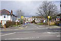
9
Junction of Goetre Fawr Road and Broadmead, Killay, Swansea
Broadmead descends from the B4296 Goetre Fawr Road.
Image: © Jaggery
Taken: 18 Sep 2014
0.21 miles
10
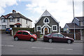
Gospel Hall on Dunvant Road
Its inscription dates it from 1928. It sits fairly unpretentiously amongst residential houses.
Image: © Bill Boaden
Taken: 6 Apr 2016
0.22 miles