IMAGES TAKEN NEAR TO
Killay, SWANSEA, SA2 7DU
Introduction
This page details the photographs taken nearby to SA2 7DU by members of the Geograph project.
The Geograph project started in 2005 with the aim of publishing, organising and preserving representative images for every square kilometre of Great Britain, Ireland and the Isle of Man.

There are currently over 7.5m images from over14,400 individuals and you can help contribute to the project by visiting https://www.geograph.org.uk
Image Map (Loading...)


Getting Data...Please wait
Leaflet Map data © OpenStreetMap
Images are licensed for reuse under creativecommons.org/licenses/by-sa/2.0
Notes
- Clicking on the map will re-center to the selected point.
- The higher the marker number, the further away the image location is from the centre of the postcode.
Image Listing (34 Images Found)
Images are licensed for reuse under creativecommons.org/licenses/by-sa/2.0
Image
Details
Distance
1
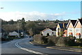
Gower Road, Killay
The double bend takes the road over the Clyne Trail via a former railway bridge.
Image: © john bristow
Taken: 26 Dec 2013
0.09 miles
2
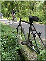
Cycle lane
A rusty cycle frame stands embedded in a log alongside the cycle track through Clyne Country Park.
Image: © Alan Hughes
Taken: 26 May 2020
0.11 miles
3
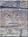
Ordnance Survey Cut Mark
This inverted OS cut mark can be found at the entrance to No514 Gower Road. It marks a point 58.961m above mean sea level.
Image: © Adrian Dust
Taken: 13 Dec 2015
0.11 miles
4
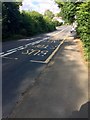
Bus Stop
Bus stop on Gower Road between Killay and Upper Killay.
Image: © Alan Hughes
Taken: 23 Jul 2018
0.11 miles
5
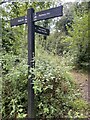
Dyffryn Clun signpost
Signpost on the Clyne Valley cycle track.
Image: © Alan Hughes
Taken: 20 Sep 2022
0.12 miles
6
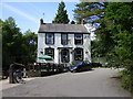
The Railway Inn, Killay
Public House next to the former Heart of Wales Line. The line was closed under the 'Beeching Axe' in the 1960's and this section of it is now a public path and cycle route.
Image: © Peter Shaw
Taken: 2 Aug 2010
0.14 miles
7
The Railway Inn
A glimpse of the Railway Inn at Killay. The disused railway is now a cycle track.
Image: © Alan Hughes
Taken: 23 Jul 2018
0.15 miles
8
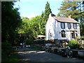
The Railway Inn, Killay
Looking north-west from the Clyne Trail cycle path, part of National Cycle Route 4. Killay Station used to be on the site now used as the pub car park to the right of this picture, but all the buildings have been demolished. The bridge on the left carries the A4118 Gower Road over the old railway line.
Image: © Simon Mortimer
Taken: 9 Aug 2012
0.15 miles
9
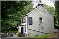
The Railway Inn
A convenient watering place for those using the Clyne Trail.
Image: © john bristow
Taken: 8 Aug 2012
0.15 miles
10
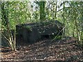
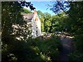
Pillbox on the east side of Clyne railway cutting
This is one of a pair of pillboxes guarding each side of a bridge over the former railway in Clyne Valley. The view here is from the lane that continues south from Clyne Valley Cottages.
Image: © Nigel Davies
Taken: 18 Apr 2015
0.15 miles