IMAGES TAKEN NEAR TO
Heol Glasnant, SWANSEA, SA2 7BX
Introduction
This page details the photographs taken nearby to Heol Glasnant, SA2 7BX by members of the Geograph project.
The Geograph project started in 2005 with the aim of publishing, organising and preserving representative images for every square kilometre of Great Britain, Ireland and the Isle of Man.

There are currently over 7.5m images from over14,400 individuals and you can help contribute to the project by visiting https://www.geograph.org.uk
Image Map
Images are licensed for reuse under creativecommons.org/licenses/by-sa/2.0
Notes
- Clicking on the map will re-center to the selected point.
- The higher the marker number, the further away the image location is from the centre of the postcode.
Image Listing (17 Images Found)
Images are licensed for reuse under creativecommons.org/licenses/by-sa/2.0
Image
Details
Distance
1

Ordnance Survey Cut Mark
This OS cut mark can be found on the Sub-Station SW side of Wimmerfield Drive. It marks a point 98.990m above mean sea level.
Image: © Adrian Dust
Taken: 28 Jan 2021
0.11 miles
2
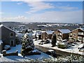
Killay Snow
View from Bron-y-bryn towards Hendrefoilan Road
Image: © Rachel Thomas
Taken: Unknown
0.15 miles
4

Cae Banadl electricity substation, Killay, Swansea
The identifier on the Western Power Distribution electricity substation in Cygnet Close is
CAE BANADL KILLAY S/S 524508.
Image: © Jaggery
Taken: 18 Sep 2014
0.21 miles
5
Cygnet Close, Killay, Swansea
On the north side of Gower Road.
Image: © Jaggery
Taken: 18 Sep 2014
0.21 miles
7
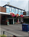
The Village Inn, Killay, Swansea
Located at 5-6 Swan Court, The Precinct.
Image: © Jaggery
Taken: 18 Sep 2014
0.22 miles
8

Pipkins Day Nursery, Killay, Swansea
Located in The Precinct, viewed across Cygnet Close.
Image: © Jaggery
Taken: 18 Sep 2014
0.22 miles
9

Killay Dental Health Centre, Swansea
At 11 Cygnet Close, north of Gower Road.
Image: © Jaggery
Taken: 18 Sep 2014
0.22 miles
10

Ordnance Survey Cut Mark
This OS cut mark can be found on the wall of No393 Gower Road. It marks a point 79.641m above mean sea level.
Image: © Adrian Dust
Taken: 28 Jan 2021
0.23 miles