IMAGES TAKEN NEAR TO
St. Christopher Drive, SWANSEA, SA2 7AR
Introduction
This page details the photographs taken nearby to St. Christopher Drive, SA2 7AR by members of the Geograph project.
The Geograph project started in 2005 with the aim of publishing, organising and preserving representative images for every square kilometre of Great Britain, Ireland and the Isle of Man.

There are currently over 7.5m images from over14,400 individuals and you can help contribute to the project by visiting https://www.geograph.org.uk
Image Map
Images are licensed for reuse under creativecommons.org/licenses/by-sa/2.0
Notes
- Clicking on the map will re-center to the selected point.
- The higher the marker number, the further away the image location is from the centre of the postcode.
Image Listing (39 Images Found)
Images are licensed for reuse under creativecommons.org/licenses/by-sa/2.0
Image
Details
Distance
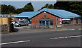
1
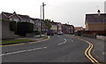
Ridgeway, Killay, Swansea
Looking SSW along Ridgeway from near the entrance http://www.geograph.org.uk/photo/4171825 to Killay Library.
Image: © Jaggery
Taken: 18 Sep 2014
0.06 miles
2
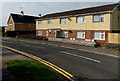
Ridgeway Court, Killay, Swansea
Flats viewed across the street named Ridgeway.
Image: © Jaggery
Taken: 18 Sep 2014
0.07 miles
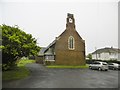
4
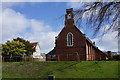
St Hilary's Church, Killay
A red brick Anglican church consecrated in 1926.
Image: © Bill Boaden
Taken: 6 Apr 2016
0.08 miles
5
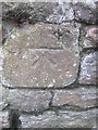
Ordnance Survey Cut Mark
This OS cut mark can be found on the wall of No471 Gower Road. It marks a point 70.796m above mean sea level.
Image: © Adrian Dust
Taken: 13 Dec 2015
0.09 miles
6
Killay, St. Hilary's
Parish church on Gower Road: http://parish.churchinwales.org.uk/s432/churches-en/st-hilary_-en/
Image: © Mike Faherty
Taken: 16 Jul 2016
0.09 miles
7
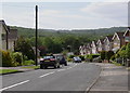
Ridgeway, Killay
In the distance is Fairwood Common
Image: © john bristow
Taken: 8 Jun 2012
0.09 miles
8
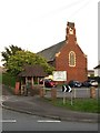
St.Hilary's Church, Killay
A red brick church with fine stained windows. Consecrated in 1926.
Image: © Alan Hughes
Taken: 6 Apr 2017
0.09 miles
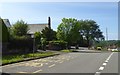
9

Gower Road, Killay, Swansea
The A4118 Gower Road heads SSW towards Upper Killay, past the Woodside Avenue
junction on the left. Defy-Time cosmetic clinic and medical spa is on the right.
Image: © Jaggery
Taken: 18 Sep 2014
0.10 miles
10
Entrance to Killay Library, Swansea
From Ridgeway near the Goetre Fawr Road junction.
Killay Library is part of the City and County of Swansea Library Service.
Image: © Jaggery
Taken: 18 Sep 2014
0.10 miles