IMAGES TAKEN NEAR TO
Townhill Gardens, SWANSEA, SA2 0YP
Introduction
This page details the photographs taken nearby to Townhill Gardens, SA2 0YP by members of the Geograph project.
The Geograph project started in 2005 with the aim of publishing, organising and preserving representative images for every square kilometre of Great Britain, Ireland and the Isle of Man.

There are currently over 7.5m images from over14,400 individuals and you can help contribute to the project by visiting https://www.geograph.org.uk
Image Map
Images are licensed for reuse under creativecommons.org/licenses/by-sa/2.0
Notes
- Clicking on the map will re-center to the selected point.
- The higher the marker number, the further away the image location is from the centre of the postcode.
Image Listing (11 Images Found)
Images are licensed for reuse under creativecommons.org/licenses/by-sa/2.0
Image
Details
Distance
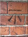
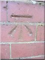
1
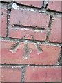
Ordnance Survey Cut Mark
This OS cut mark can be found on the wall of No123 Town Hill Road. It marks a point 161.581m above mean sea level.
Image: © Adrian Dust
Taken: 5 Dec 2013
0.03 miles
2
Ordnance Survey Cut Mark
This OS cut mark can be found on the wall of No109 Pant-Y-Celyn Road. It marks a point 146.603m above mean sea level.
Image: © Adrian Dust
Taken: 5 Dec 2013
0.08 miles
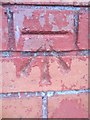
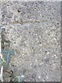
3
Ordnance Survey Cut Mark
This OS cut mark can be found on No150 Town Hill Road. It marks a point 171.901m above mean sea level.
Image: © Adrian Dust
Taken: 5 Dec 2013
0.12 miles
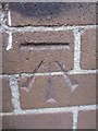
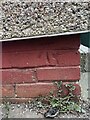
4
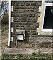
NEW
Benchmark on 150 Townhill Road Swansea
An Ordnance Survey Benchmark can be found on the South East Face of 150 Townhill Road Swansea. It marks a height of 171.901m above mean sea level.
Image: © John Jenkins
Taken: 11 Mar 2025
0.12 miles
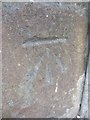
5
Ordnance Survey Cut Mark
This OS cut mark can be found on the wall of No11 Elwy Crescent. It marks a point 161.440m above mean sea level.
Image: © Adrian Dust
Taken: 12 Mar 2014
0.13 miles
6
Ordnance Survey Cut Mark
This OS cut mark can be found on the NW face of a building (Hostel) on the Town Hill Campus of Swansea Metropolitan University. It marks a point 148.764m above mean sea level.
Image: © Adrian Dust
Taken: 5 Dec 2013
0.15 miles
7
Ordnance Survey Cut Mark
This OS cut mark can be found on the concrete gate post adjacent to No81 Graig Lwyd. It marks a point 163.016m above mean sea level.
Image: © Adrian Dust
Taken: 12 Mar 2014
0.17 miles
8
Ordnance Survey Cut Mark
This OS cut mark can be found at the junction of Elwy Crescent & Gwynedd Avenue. It marks a point 155.338m above mean sea level.
Image: © Adrian Dust
Taken: 12 Mar 2014
0.18 miles
9
Ordnance Survey cut Mark
This OS cut mark can be found on the wall of No203 Gwynedd Avenue. It marks a point 144.561m above mean sea level.
Image: © Adrian Dust
Taken: 12 Mar 2014
0.20 miles
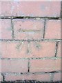
10
NEW
Benchmark on 44 Ceri Road Townhill Swansea
An Ordnance Survey Benchmark can be found on the East face of 44 Ceri Road, Townhill, Swansea. It marks a height of 146.143m above mean sea level.
Image: © John Jenkins
Taken: 11 Mar 2025
0.23 miles