IMAGES TAKEN NEAR TO
Lon Cwmgwyn, SWANSEA, SA2 0TY
Introduction
This page details the photographs taken nearby to Lon Cwmgwyn, SA2 0TY by members of the Geograph project.
The Geograph project started in 2005 with the aim of publishing, organising and preserving representative images for every square kilometre of Great Britain, Ireland and the Isle of Man.

There are currently over 7.5m images from over14,400 individuals and you can help contribute to the project by visiting https://www.geograph.org.uk
Image Map (Loading...)


Getting Data...Please wait
Leaflet Map data © OpenStreetMap
Images are licensed for reuse under creativecommons.org/licenses/by-sa/2.0
Notes
- Clicking on the map will re-center to the selected point.
- The higher the marker number, the further away the image location is from the centre of the postcode.
Image Listing (8 Images Found)
Images are licensed for reuse under creativecommons.org/licenses/by-sa/2.0
Image
Details
Distance
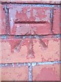
1
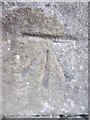
Ordnance Survey Cut Mark
This OS cut mark can be found on the wall of No1 Lon Ger-Y-Coed. It marks a point 133.332m above mean sea level.
Image: © Adrian Dust
Taken: 5 Dec 2013
0.08 miles
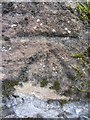
2
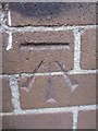
Ordnance Survey Cut Mark
This OS cut mark can be found on the NW face of a building (Hostel) on the Town Hill Campus of Swansea Metropolitan University. It marks a point 148.764m above mean sea level.
Image: © Adrian Dust
Taken: 5 Dec 2013
0.08 miles
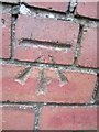
4
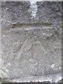
Ordnance Survey Cut Mark
This OS cut mark can be found on the gatepost of No163 Glanmor Road. It marks a point 91.397m above mean sea level.
Image: © Adrian Dust
Taken: 5 Dec 2013
0.18 miles
6
Ordnance Survey Cut Mark
This OS cut mark can be found on the wall of No109 Pant-Y-Celyn Road. It marks a point 146.603m above mean sea level.
Image: © Adrian Dust
Taken: 5 Dec 2013
0.21 miles
7
Ordnance Survey Cut Mark
This OS cut mark can be found on a wall to the north side of Penlan Crescent. It marks a point 98.057m above mean sea level.
Image: © Adrian Dust
Taken: 5 Dec 2013
0.21 miles
8
Ordnance Survey Cut Mark
This OS cut mark can be found on the wall of No123 Town Hill Road. It marks a point 161.581m above mean sea level.
Image: © Adrian Dust
Taken: 5 Dec 2013
0.21 miles