IMAGES TAKEN NEAR TO
Tavistock Close, SWANSEA, SA2 0SU
Introduction
This page details the photographs taken nearby to Tavistock Close, SA2 0SU by members of the Geograph project.
The Geograph project started in 2005 with the aim of publishing, organising and preserving representative images for every square kilometre of Great Britain, Ireland and the Isle of Man.

There are currently over 7.5m images from over14,400 individuals and you can help contribute to the project by visiting https://www.geograph.org.uk
Image Map
Images are licensed for reuse under creativecommons.org/licenses/by-sa/2.0
Notes
- Clicking on the map will re-center to the selected point.
- The higher the marker number, the further away the image location is from the centre of the postcode.
Image Listing (38 Images Found)
Images are licensed for reuse under creativecommons.org/licenses/by-sa/2.0
Image
Details
Distance
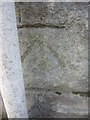
1

Ordnance Survey Cut Mark
This OS cut mark can be found on north angle of No34 Parc Wern Road. It marks a point 63.667m above mean sea level.
Image: © Adrian Dust
Taken: 5 Dec 2013
0.06 miles
2

Ordnance Survey Cut Mark
This OS cut mark can be found on the wall of No10 Queens Road. It marks a point 67.343m above mean sea level.
Image: © Adrian Dust
Taken: 5 Dec 2013
0.06 miles
4
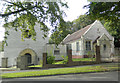
Capel y Trinity, Swansea
Eglwys Bresbyteraidd Cymru / Presbyterian Church of Wales
Image: © John Lord
Taken: 6 Oct 2017
0.10 miles
5

Ordnance Survey Cut Mark
This OS cut mark can be found on the wall of No31 Parc Wern Road. It marks a point 81.394m above mean sea level.
Image: © Adrian Dust
Taken: 5 Dec 2013
0.11 miles
6
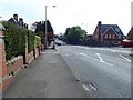
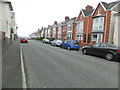
Sketty Avenue
To the north west of Swansea is a ridge covered by residential areas with some very steep gradients. This is near the western end of the ridge, with some of the gradient in view.
Image: © Bill Boaden
Taken: 5 Apr 2016
0.12 miles
8
Ordnance Survey Cut Mark
This OS cut mark can be found on the wall of No20 Gower Road. It marks a point 49.012m above mean sea level.
Image: © Adrian Dust
Taken: 7 Feb 2014
0.15 miles
9
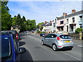
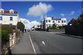
Sketty Road, Swansea
Looking west, the lodge for Singleton Park is ahead on the left. It is a Mid C19 lodge to the former Singleton Abbey estate and is Grade II listed.
Image: © Eirian Evans
Taken: 7 May 2019
0.15 miles