IMAGES TAKEN NEAR TO
Sketty Road, SWANSEA, SA2 0NL
Introduction
This page details the photographs taken nearby to Sketty Road, SA2 0NL by members of the Geograph project.
The Geograph project started in 2005 with the aim of publishing, organising and preserving representative images for every square kilometre of Great Britain, Ireland and the Isle of Man.

There are currently over 7.5m images from over14,400 individuals and you can help contribute to the project by visiting https://www.geograph.org.uk
Image Map (Loading...)


Getting Data...Please wait
Leaflet Map data © OpenStreetMap
Images are licensed for reuse under creativecommons.org/licenses/by-sa/2.0
Notes
- Clicking on the map will re-center to the selected point.
- The higher the marker number, the further away the image location is from the centre of the postcode.
Image Listing (76 Images Found)
Images are licensed for reuse under creativecommons.org/licenses/by-sa/2.0
Image
Details
Distance
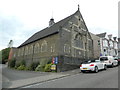
1
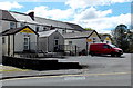
Hurst Dene Hotel car park, Uplands, Swansea
The car park is on the Glanmor Road side of Hurst Dene. The front of the hotel is alongside Sketty Road.
Image: © Jaggery
Taken: 27 Apr 2014
0.05 miles
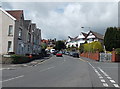
2
Windsor Street, Swansea
Looking west from the corner of Glanmor Road and Glanmor Crescent.
Image: © Jaggery
Taken: 27 Apr 2014
0.05 miles
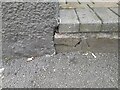
3

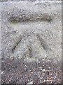
Ordnance Survey Rivet
This OS rivet can be found on the wall of No17 Glanmor Road. It marks a point 62.451m above mean sea level.
Image: © Adrian Dust
Taken: 5 Dec 2013
0.06 miles
5
Ordnance Survey Cut Mark
This OS cut mark can be found on the wall on Sketty Road at the junction with Hawthorne Avenue. It marks a point 49.786m above mean sea level.
Image: © Adrian Dust
Taken: 5 Dec 2013
0.08 miles
6
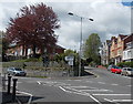
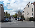
Junction in Uplands Swansea
The A4118 Sketty Road is on the left, Glanmor Road on the right.
Image: © Jaggery
Taken: 27 Apr 2014
0.08 miles
8

Ordnance Survey Cut Mark
This OS cut mark can be found on the wall of No6 Bernard Street. It marks a point 44.885m above mean sea level.
Image: © Adrian Dust
Taken: 5 Dec 2013
0.08 miles
9
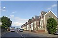
Glanmor Road, Swansea
Glanmor Road heads NW away from the Windsor Street http://www.geograph.org.uk/photo/4092003 junction
on the left and the Glanmor Crescent junction on the right.
Image: © Jaggery
Taken: 27 Apr 2014
0.09 miles
10
Ordnance Survey Cut Mark
This OS cut mark can be found on the step of No3 Sketty Road. It marks a point 47.040m above mean sea level.
Image: © Adrian Dust
Taken: 19 Sep 2022
0.09 miles