IMAGES TAKEN NEAR TO
Beechwood Road, SWANSEA, SA2 0JD
Introduction
This page details the photographs taken nearby to Beechwood Road, SA2 0JD by members of the Geograph project.
The Geograph project started in 2005 with the aim of publishing, organising and preserving representative images for every square kilometre of Great Britain, Ireland and the Isle of Man.

There are currently over 7.5m images from over14,400 individuals and you can help contribute to the project by visiting https://www.geograph.org.uk
Image Map
Images are licensed for reuse under creativecommons.org/licenses/by-sa/2.0
Notes
- Clicking on the map will re-center to the selected point.
- The higher the marker number, the further away the image location is from the centre of the postcode.
Image Listing (54 Images Found)
Images are licensed for reuse under creativecommons.org/licenses/by-sa/2.0
Image
Details
Distance
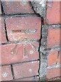
1
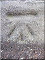
Ordnance Survey Cut Mark
This OS cut mark can be found on the wall on Sketty Road at the junction with Hawthorne Avenue. It marks a point 49.786m above mean sea level.
Image: © Adrian Dust
Taken: 5 Dec 2013
0.07 miles
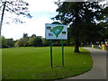
2
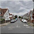
Knoll Avenue
Viewed from the north entrance to Brynmill Park.
Image: © Z Pryce
Taken: 18 Jun 2021
0.07 miles
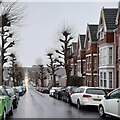
3
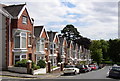
Knoll Avenue
This street is typical of the attractive terrace housing in the Brynmill area and also illustrates the hilly nature of much of Swansea.
Image: © john bristow
Taken: 27 Jul 2012
0.08 miles
4

Ordnance Survey Cut Mark
This OS cut mark can be found on the wall of No6 Bernard Street. It marks a point 44.885m above mean sea level.
Image: © Adrian Dust
Taken: 5 Dec 2013
0.09 miles
5
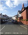
Le-Breos Avenue, Uplands
One of many residential roads leading from Sketty Road
Image: © David Smith
Taken: 3 Jun 2018
0.09 miles
8
Bernard Street
This road runs from Sketty Road into the heart of Brynmill, a neighbourhood popular with students of nearby Swansea University.
Image: © Z Pryce
Taken: 13 Feb 2022
0.11 miles
9

Ordnance Survey Cut Mark
This OS cut mark can be found on the wall between Nos. 80 & 82 Gower Road. It marks a point 50.856m above mean sea level.
Image: © Adrian Dust
Taken: 5 Dec 2013
0.12 miles
10
Ordnance Survey Cut Mark
This OS cut mark can be found on the wall of No31 Glanbrydan Avenue. It marks a point 33.373m above mean sea level.
Image: © Adrian Dust
Taken: 28 Jan 2015
0.12 miles