IMAGES TAKEN NEAR TO
Waterloo Place, SWANSEA, SA2 0DE
Introduction
This page details the photographs taken nearby to Waterloo Place, SA2 0DE by members of the Geograph project.
The Geograph project started in 2005 with the aim of publishing, organising and preserving representative images for every square kilometre of Great Britain, Ireland and the Isle of Man.

There are currently over 7.5m images from over14,400 individuals and you can help contribute to the project by visiting https://www.geograph.org.uk
Image Map (Loading...)


Getting Data...Please wait
Leaflet Map data © OpenStreetMap
Images are licensed for reuse under creativecommons.org/licenses/by-sa/2.0
Notes
- Clicking on the map will re-center to the selected point.
- The higher the marker number, the further away the image location is from the centre of the postcode.
Image Listing (39 Images Found)
Images are licensed for reuse under creativecommons.org/licenses/by-sa/2.0
Image
Details
Distance
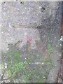
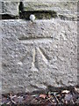
1
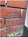
Ordnance Survey Cut Mark
This OS cut mark can be found on the wall of No68 Alexandria Terrace. It marks a point 28.889m above mean sea level.
Image: © Adrian Dust
Taken: 28 Jan 2015
0.04 miles
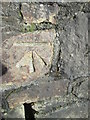
2
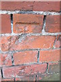
Ordnance Survey Cut Mark
This damaged OS cut mark can be found on the north face of The Rhyddings Public House. It marks a point 36.780m above mean sea level.
Image: © Adrian Dust
Taken: 28 Jan 2015
0.07 miles
3
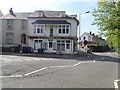
Brynmill Coffee House
Half way down Brynmill Terrace.
Image: © Eirian Evans
Taken: 7 May 2019
0.08 miles
4
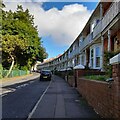
Oakwood Road, Brynmill
An attractive row of terrace houses overlooking Brynmill Park.
Image: © Z Pryce
Taken: 1 Oct 2021
0.09 miles
5
Ordnance Survey Cut Mark
This OS cut mark can be found on the gatepost of the entrance to Singleton Park on Brynmill Lane. It marks a point 18.373m above mean sea level.
Image: © Adrian Dust
Taken: 28 Jan 2015
0.09 miles
6
Ordnance Survey Cut Mark
This OS cut mark can be found on the wall of Brynmill Primary School. It marks a point 29.813m above mean sea level.
Image: © Adrian Dust
Taken: 28 Jan 2015
0.11 miles
7
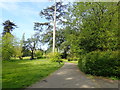
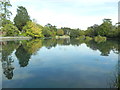
Singleton Park
Eastern entrance to the park, half way down Brynmill Terrace. The park was originally part of the Vivian family estate, which was purchased by Swansea County Borough Council in 1919 for use as a public park
Image: © Eirian Evans
Taken: 7 May 2019
0.12 miles
8
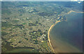
Swansea from the air, 1998
With the University at lower centre, and the docks by the mouth of the River Tawe. At top right, the River Neath meets the sea.
Image: © Derek Harper
Taken: 1 Jun 1998
0.12 miles
10
Ordnance Survey Cut Mark
This OS cut mark can be found on the roadside wall below NO21 Brynmill Lane. It marks a point 16.767m above mean sea level.
Image: © Adrian Dust
Taken: 28 Jan 2015
0.13 miles