IMAGES TAKEN NEAR TO
LLANDOVERY, SA20 0YR
Introduction
This page details the photographs taken nearby to SA20 0YR by members of the Geograph project.
The Geograph project started in 2005 with the aim of publishing, organising and preserving representative images for every square kilometre of Great Britain, Ireland and the Isle of Man.

There are currently over 7.5m images from over14,400 individuals and you can help contribute to the project by visiting https://www.geograph.org.uk
Image Map (Loading...)


Getting Data...Please wait
Leaflet Map data © OpenStreetMap
Images are licensed for reuse under creativecommons.org/licenses/by-sa/2.0
Notes
- Clicking on the map will re-center to the selected point.
- The higher the marker number, the further away the image location is from the centre of the postcode.
Image Listing (5 Images Found)
Images are licensed for reuse under creativecommons.org/licenses/by-sa/2.0
Image
Details
Distance
1
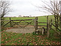
Llwybr ger Ffarm y Cefn / Path near Cefn Farm
Llwybr cyhoeddus ger Farm y Cefn yn mynd i gyfeiriad pentre Cynghordy.
A public footpath near Cefn Farm heading towards the village of Cynghordy (trans. house with dog kennels).
Image: © Alan Richards
Taken: 26 Nov 2018
0.05 miles
2
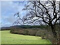
Carmarthenshire countryside
View across fields towards Cwm Crychan.
Image: © Alan Hughes
Taken: 23 Dec 2023
0.11 miles
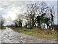
4
Lane heading to A483
Lane from Cefn Farm heading to A483
Image: © Shaun Ferguson
Taken: 24 Aug 2008
0.17 miles
5
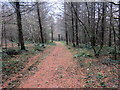
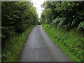
Llwybr Coedog / Wooded path
Llwybr cyhoeddus yn mynd i gyfeiriad safle hen Ffarm Penlan
A public footpath heading towards the site of the former Penlan Farm (trans. top of the hill)
Image: © Alan Richards
Taken: 23 Nov 2018
0.19 miles