1
Ordnance Survey Cut Mark
This OS cut mark can be found on the wall to the NW of the road. It marks a point 89.442m above mean sea level.
Image: © Adrian Dust
Taken: 1 Sep 2013
0.01 miles
2
St Mary's church viewed from Llanfair Grange, Llandovery
The Grade I listed church http://www.geograph.org.uk/photo/2544460 viewed from the car park of Llanfair Grange. http://www.geograph.org.uk/photo/2545748
Image: © Jaggery
Taken: 5 Jun 2011
0.01 miles
3
Stile and service reservoir building, Llanfair Hill, Llandovery
Located opposite a Grade I listed church. http://www.geograph.org.uk/photo/2544460
The stile is at the edge of a fenced-off Welsh Water site. The name plate on the building shows Llanfair Service Reservoir. It is a covered reservoir.
Image: © Jaggery
Taken: 5 Jun 2011
0.01 miles
4
Llanfair Hill, Llandovery
The NE side of Llanfair Hill is dominated by the Grade I listed St Mary's Church,
Llanfair-ar-y-bryn. http://www.geograph.org.uk/photo/2544460
Image: © Jaggery
Taken: 5 Jun 2011
0.01 miles
5
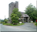
Grade I listed church, Llandovery
This is the tower and lych gate of St Mary's, Llanfair-ar-y-bryn. The church has 14th-15th century origins, with restoration work in the early 20th century. The church was built on the site of the Roman station of Loventium. Grade I listed in August 1966.
Image: © Jaggery
Taken: 5 Jun 2011
0.01 miles
6
Steps up the churchyard wall of St Mary's, Llanfair-ar-y-bryn
Image: © Jeff Gogarty
Taken: 16 Sep 2022
0.04 miles
7
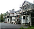
Scaffolding on Llanfair Grange, Llandovery
Llanfair Grange is a residential care home on Llanfair Hill, located near the Grade I listed St Mary's church. http://www.geograph.org.uk/photo/2544460
Image: © Jaggery
Taken: 5 Jun 2011
0.05 miles
8
Path to the door of St Mary's, Llanfair-ar-y-bryn
Image: © Jeff Gogarty
Taken: 16 Sep 2022
0.05 miles
9
Ordnance Survey Cut Mark with Bolt
This OS cut mark can be found on the SW face of the church tower. It marks a point 93.494m above mean sea level.
Image: © Adrian Dust
Taken: 1 Sep 2013
0.05 miles
10
Bend in the A483, Llandovery
The A483 is here named Llanfair Road, at the NE edge of Llandovery.
Image: © Jaggery
Taken: 5 Jun 2011
0.06 miles


