IMAGES TAKEN NEAR TO
LLANDOVERY, SA20 0TT
Introduction
This page details the photographs taken nearby to SA20 0TT by members of the Geograph project.
The Geograph project started in 2005 with the aim of publishing, organising and preserving representative images for every square kilometre of Great Britain, Ireland and the Isle of Man.

There are currently over 7.5m images from over14,400 individuals and you can help contribute to the project by visiting https://www.geograph.org.uk
Image Map
Images are licensed for reuse under creativecommons.org/licenses/by-sa/2.0
Notes
- Clicking on the map will re-center to the selected point.
- The higher the marker number, the further away the image location is from the centre of the postcode.
Image Listing (9 Images Found)
Images are licensed for reuse under creativecommons.org/licenses/by-sa/2.0
Image
Details
Distance
1
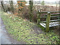
Snowdrops beside the footbridge
Here are some definite signs that Spring is eventually warming the soil a little, at last.
Image: © Jeremy Bolwell
Taken: 6 Feb 2011
0.12 miles
2
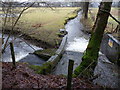
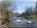
Fork in the stream near Llandovery
The concrete and brick structure here enables the fast flowing waters of this stream to be diverted in two directions across fields leading towards the Afon Tywi.
Image: © Jeremy Bolwell
Taken: 6 Feb 2011
0.13 miles
4
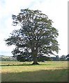
Tree in field at Tonn, Llandovery
This magnificent lone tree stands out against the surrounding flat land as you pass by on the right of way.
Image: © Nigel Davies
Taken: 5 Aug 2007
0.15 miles
5
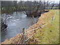
River bank erosion on the Afon Tywi near Llandovery
It seems that a back eddy has been able to undercut this section of riverbank, isolating what was once part of a hedgerow and now even the fence posts have lost their footings. The footpath will need to be re-routed too.
Image: © Jeremy Bolwell
Taken: 6 Feb 2011
0.16 miles
6
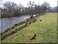
Footpath beside the Afon Tywi
Riverside walks are great any time of year. Even on a grey and wettish afternoon in early Feb.
Image: © Jeremy Bolwell
Taken: 6 Feb 2011
0.18 miles
7
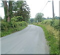
Cilycwm Road heads out of Llandovery
North of a railway bridge, http://www.geograph.org.uk/photo/2539763 Cilycwm Road changes from an urban residential road to a country road as it leaves the northern edge of Llandovery.
Image: © Jaggery
Taken: 5 Jun 2011
0.18 miles
8
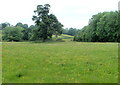
Trees in a field, Cilycwm Road, Llandovery
Viewed from Cilycwm Road a few tens of metres north of the railway bridge. http://www.geograph.org.uk/photo/2539763
Image: © Jaggery
Taken: 5 Jun 2011
0.18 miles
9
Afon Tywi near Llandovery
The OS map shows a footpath on the left bank of the river. This no longer exists, perhaps scoured by the river.
Image: © Alan Hughes
Taken: 22 Mar 2022
0.19 miles