IMAGES TAKEN NEAR TO
Halfway, LLANDOVERY, SA20 0SD
Introduction
This page details the photographs taken nearby to SA20 0SD by members of the Geograph project.
The Geograph project started in 2005 with the aim of publishing, organising and preserving representative images for every square kilometre of Great Britain, Ireland and the Isle of Man.

There are currently over 7.5m images from over14,400 individuals and you can help contribute to the project by visiting https://www.geograph.org.uk
Image Map
Images are licensed for reuse under creativecommons.org/licenses/by-sa/2.0
Notes
- Clicking on the map will re-center to the selected point.
- The higher the marker number, the further away the image location is from the centre of the postcode.
Image Listing (7 Images Found)
Images are licensed for reuse under creativecommons.org/licenses/by-sa/2.0
Image
Details
Distance
1
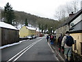
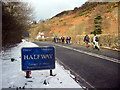
Pentref Halfway - Halfway Village
Cerddwyr yn cyrraedd pentre Halfway. Y ty melyn ar y chwith yw'r hen Halfway Inn a roes yr enw i'r pentre.
Walkers arriving at the village of Halfway. The yellow house on the left is the former Halfway Inn which gave the village its name.
Image: © Alan Richards
Taken: 5 Mar 2006
0.01 miles
2
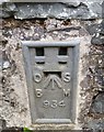
Ordnance Survey Flush Bracket (934)
This OS Flush Bracket can be found on the south face of the Bethesda Chapel. It marks a point 136.979m above mean sea level.
Image: © Adrian Dust
Taken: 7 Apr 2019
0.10 miles
3
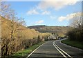
A 40 at Halfway
But from where to where? I have a very vague memory of discussing this nearly 60 years ago while heading west with my parents from Sennybridge to Pembrokeshire. This is the A40 heading up the valley of the Afon Gwydderig.
Image: © Derek Harper
Taken: 2 Jan 2015
0.13 miles
4
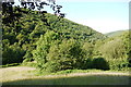
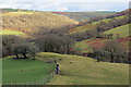
Woods above Halfway
View across the valley to the woods on the northern slopes above the small hamlet from the bottom of the gated road on the other side of the valley that leads up to Llanerch Goch
Image: © Nigel Mykura
Taken: 2 Jul 2015
0.15 miles
5
Llwybr i Halfway / Path to Halfway
Llwybr cyhoeddus yn mynd i lawr y waered i gyfeiriad pentref Halfway.
A public footpath descending towards the village of Halfway.
Image: © Alan Richards
Taken: 4 Mar 2022
0.16 miles
6
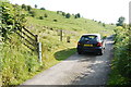
Gated Road to Llanerch Goch
This is the lower part of the gated road that runs from Halfway on the A40 The fence and noticeboards mark the start of the access land that surround the roman camp and forts on Y Pigwn. The land is all rough pasture.
Image: © Nigel Mykura
Taken: 2 Jul 2015
0.16 miles
7
Pentref Halfway / Halfway Village
Cerddwyr yn cyrraedd pentref Halfway.
Walkers arriving at the village of Halfway.
Image: © Alan Richards
Taken: 5 Mar 2006
0.23 miles