IMAGES TAKEN NEAR TO
Myddfai, LLANDOVERY, SA20 0QF
Introduction
This page details the photographs taken nearby to SA20 0QF by members of the Geograph project.
The Geograph project started in 2005 with the aim of publishing, organising and preserving representative images for every square kilometre of Great Britain, Ireland and the Isle of Man.

There are currently over 7.5m images from over14,400 individuals and you can help contribute to the project by visiting https://www.geograph.org.uk
Image Map (Loading...)


Getting Data...Please wait
Leaflet Map data © OpenStreetMap
Images are licensed for reuse under creativecommons.org/licenses/by-sa/2.0
Notes
- Clicking on the map will re-center to the selected point.
- The higher the marker number, the further away the image location is from the centre of the postcode.
Image Listing (1 Images Found)
Images are licensed for reuse under creativecommons.org/licenses/by-sa/2.0
Image
Details
Distance
1
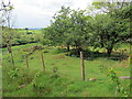
Black Cock Inn
Gweddillion pitw y Black Cock Inn a safai'r wrth ochr yr heol Rufeinig a'r hen ffordd goets fawr. Yn 1769, wrth i weithwyr gwella'r ffordd dyrpeg yn y lleoliad hwn, fe ddaethpwyd o hyd i garreg filltir Rufeing gydag enw Postimus wedi ei harysgrifio ar un ochr a Victorinus ar y llall. Aethpwyd â'r garreg i Landeilo ond credir ei bod hi bellach yn anffodus ar goll.
The scant remains of the Black Cock Inn located on the old Roman road and later coach route. At this location in 1769 workers, while improving the turnpike road, unearthed a Roman milestone with the name Postimus inscribed on one side and Victorinus on the other. The stone was removed to Llandeilo but unfortunately it is now believed to be lost.
Image: © Alan Richards
Taken: 29 May 2022
0.24 miles