IMAGES TAKEN NEAR TO
Rhandirmwyn, LLANDOVERY, SA20 0PA
Introduction
This page details the photographs taken nearby to SA20 0PA by members of the Geograph project.
The Geograph project started in 2005 with the aim of publishing, organising and preserving representative images for every square kilometre of Great Britain, Ireland and the Isle of Man.

There are currently over 7.5m images from over14,400 individuals and you can help contribute to the project by visiting https://www.geograph.org.uk
Image Map (7 Images)


Getting Data...Please wait
Leaflet Map data © OpenStreetMap
Images are licensed for reuse under creativecommons.org/licenses/by-sa/2.0
Notes
- Clicking on the map will re-center to the selected point.
- The higher the marker number, the further away the image location is from the centre of the postcode.
Image Listing (7 Images Found)
Images are licensed for reuse under creativecommons.org/licenses/by-sa/2.0
Image
Details
Distance
1
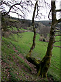
Hill pasture near Rhandirmwyn, Carmarthenshire
This steep slope soon levels out to the Tywi valley bottom which is wider than in many parts.
Image: © Roger D Kidd
Taken: 2 Apr 2011
0.08 miles
3
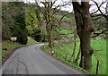
The road to Rhandirmwyn, Carmarthenshire
This is the road from Llyn Brianne approaching the village. The land to the right dips steeply towards the valley bottom which is wider than further to the north.
Image: © Roger D Kidd
Taken: 2 Apr 2011
0.10 miles
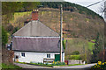
5
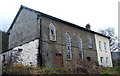
Capel Salem / Salem Chapel
Salem, Capel y Methodistiad yn Rhandirmwyn. Codwyd yr addoldy presennol yn 1852 ac yn 1869 chwythwyd y to bant gan storm. Fe'i hadnewyddwyd yn 1886 ond yn sgil lleihad o ran niferoedd a darganfod pren pydredig fe gaewyd y drysau am y tro olaf yn 1995.
Salem Methodist Chapel in Rhandirmwyn. The present chapel was built in 1852 and in 1869 the roof was blown off during a storm. Renovated in 1886 but due to dwindling numbers and the onset of dry rot the chapel closed its doors for the last time, sadly, in 1995.
Image: © Alan Richards
Taken: 25 Feb 2007
0.16 miles
6
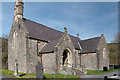
The Parish Church of St Barnabas - Rhandirmwyn
Image: © Mick Lobb
Taken: 6 Apr 2011
0.24 miles
7
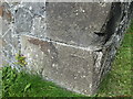
Ordnance Survey Cut Mark
This OS cut mark can be found on the SE angle of the church of St Barnabas. It marks a point 123.813m above mean sea level.
Image: © Adrian Dust
Taken: 7 Sep 2014
0.25 miles