IMAGES TAKEN NEAR TO
LLANDOVERY, SA20 0EX
Introduction
This page details the photographs taken nearby to SA20 0EX by members of the Geograph project.
The Geograph project started in 2005 with the aim of publishing, organising and preserving representative images for every square kilometre of Great Britain, Ireland and the Isle of Man.

There are currently over 7.5m images from over14,400 individuals and you can help contribute to the project by visiting https://www.geograph.org.uk
Image Map
Images are licensed for reuse under creativecommons.org/licenses/by-sa/2.0
Notes
- Clicking on the map will re-center to the selected point.
- The higher the marker number, the further away the image location is from the centre of the postcode.
Image Listing (2 Images Found)
Images are licensed for reuse under creativecommons.org/licenses/by-sa/2.0
Image
Details
Distance
1
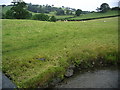
Fields rising up To Pentir-b?ch
Photo taken from Pont Goleugoed (visible bottom left) with Lletty-Ifan-Ddu visible near top, centre left. River is Afon Ydw.
Image: © Bonelli
Taken: 5 Jul 2007
0.22 miles
2
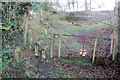
Llwybr uwchben Lletty-Ifan-Ddu / Path above Llety-Ifan-Ddu
Llwybr troed cyhoeddus uwchben Llety-Ifan-Ddu. Mae'r llwybr hirbell Lein Calon Cymru hefyd yn dod y ffordd hon.
A public footpath above Llety-Ifan-Ddu (trans. black Ifan's above). The Heart of Wales Line long distance footpath also comes this way.
Image: © Alan Richards
Taken: 17 Jan 2022
0.23 miles