IMAGES TAKEN NEAR TO
LLANDOVERY, SA20 0DX
Introduction
This page details the photographs taken nearby to SA20 0DX by members of the Geograph project.
The Geograph project started in 2005 with the aim of publishing, organising and preserving representative images for every square kilometre of Great Britain, Ireland and the Isle of Man.

There are currently over 7.5m images from over14,400 individuals and you can help contribute to the project by visiting https://www.geograph.org.uk
Image Map
Images are licensed for reuse under creativecommons.org/licenses/by-sa/2.0
Notes
- Clicking on the map will re-center to the selected point.
- The higher the marker number, the further away the image location is from the centre of the postcode.
Image Listing (3 Images Found)
Images are licensed for reuse under creativecommons.org/licenses/by-sa/2.0
Image
Details
Distance
1
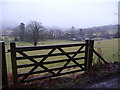
Gate overlooking Cwm-Rhuddan
This impressive looking country property just outside Llandovery must have been someone's pride and joy when first built. It now operates as a B&B I believe.
Image: © Jeremy Bolwell
Taken: 6 Feb 2011
0.20 miles
2
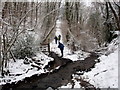
Rhyd yn yr eira / Ford in the snow
Llwybr cyhoeddus yn rhydio nant [Rhuddan?].
A public footpath fording a stream [Rhuddan?].
Image: © Alan Richards
Taken: 31 Jan 2010
0.22 miles
3
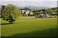
Cwm-Rhuddan, near Llandovery
View a large house and farm at Cwm-Rhuddan to the south of Llandovery.
Image: © Philip Halling
Taken: 18 May 2014
0.25 miles