1
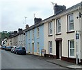
Queen Street houses near the corner of Gellideg, Llandovery
The house in the middle is painted in the claret and blue colours worn by several football teams such as Aston Villa, Burnley and West Ham United. Or perhaps these are the colours of a local sports team.
Image: © Jaggery
Taken: 5 Jun 2011
0.02 miles
2
Ebenezer Chapel
A neat building in a green enclave. The frequency of churches and chapels in this area of the town is extraordinary.
Image: © Jonathan Wilkins
Taken: 27 Jul 2007
0.03 miles
3
Houses on the east side of Gellideg, Llandovery
The houses face bungalows http://www.geograph.org.uk/photo/3185968 on the west side of the street.
Image: © Jaggery
Taken: 5 Jun 2011
0.04 miles
4
Orchard Street, Llandovery
A view north from the High Street end. The distant building is Ebenezer Baptist Chapel. http://www.geograph.org.uk/photo/3185855
Image: © Jaggery
Taken: 5 Jun 2011
0.05 miles
5
Houses on the west side of Orchard Street, Llandovery
Viewed from the corner of Queen Street looking towards the High Street junction 110 metres ahead.
The sign with a white arrow on a blue background indicates a one-way traffic system.
Image: © Jaggery
Taken: 5 Jun 2011
0.05 miles
6
Maesglas houses, Llandovery
Viewed from the corner of Gellideg.
Image: © Jaggery
Taken: 5 Jun 2011
0.05 miles
7
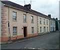
Orchard Street, Llandovery
Orchard Street houses viewed from Queen Street.
Image: © Jaggery
Taken: 5 Jun 2011
0.05 miles
8
Ebenezer Baptist Chapel, Llandovery
Set back nearly 20 metres from the north side of Queen Street and a spear type of perimeter railings. The inscription on the tablet above the doorway shows that the chapel was erected in 1844.
Image: © Jaggery
Taken: 5 Jun 2011
0.05 miles
9
Afon Br?n upstream from Pont a'r Fr?n, Llandovery
The Afon Brân, a tributary of the River Towy, flows towards this http://www.geograph.org.uk/photo/3186152 bridge.
Image: © Jaggery
Taken: 5 Jun 2011
0.06 miles
10
Bungalows on the west side of Gellideg, Llandovery
The bungalows faces 2-storey houses. http://www.geograph.org.uk/photo/3185962
Image: © Jaggery
Taken: 5 Jun 2011
0.06 miles


