IMAGES TAKEN NEAR TO
Broad Street, LLANDOVERY, SA20 0AY
Introduction
This page details the photographs taken nearby to Broad Street, SA20 0AY by members of the Geograph project.
The Geograph project started in 2005 with the aim of publishing, organising and preserving representative images for every square kilometre of Great Britain, Ireland and the Isle of Man.

There are currently over 7.5m images from over14,400 individuals and you can help contribute to the project by visiting https://www.geograph.org.uk
Image Map
Images are licensed for reuse under creativecommons.org/licenses/by-sa/2.0
Notes
- Clicking on the map will re-center to the selected point.
- The higher the marker number, the further away the image location is from the centre of the postcode.
Image Listing (174 Images Found)
Images are licensed for reuse under creativecommons.org/licenses/by-sa/2.0
Image
Details
Distance
1
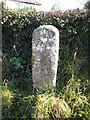
Old Milestone by the A4069, Lower Broad Street, Llandovery
By the A4069, in parish of Llandovery (Carmarthenshire District), Lower Broad Street, opposite church.
Inscription once read:- : Trecastle / 9 / Llandilo / 12 :
Surveyed
Milestone Society National ID: CAM_LDLL00.
Image: © Milestone Society
Taken: Unknown
0.01 miles
2
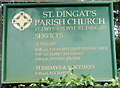
Church board, St Dingat's Parish Church, Llandovery
The board is alongside the lych gate http://www.geograph.org.uk/photo/3158509 at the Broad Street entrance to the church.
Image: © Jaggery
Taken: 5 Jun 2011
0.02 miles
3
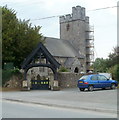
Lych gate, St Dingat's Parish Church, Llandovery
Viewed across Broad Street. The lych gate was formerly used to shelter a coffin
until the clergyman's arrival for the burial, or pre-burial service.
http://www.geograph.org.uk/photo/3158337 to a close view of the church
Image: © Jaggery
Taken: 5 Jun 2011
0.02 miles
4
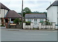
Garden Business, Llandovery
Located in single-storey premises at 42 Broad Street, opposite the College View junction.
Lettering on the windows shows that the business deals with landscaping and grounds care, and landscaping materials.
Image: © Jaggery
Taken: 5 Jun 2011
0.04 miles
7
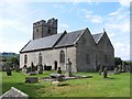
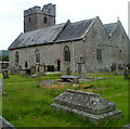
St Dingat's Church, Llandovery
Viewed from the lych gate http://www.geograph.org.uk/photo/3158509 at the edge of Broad Street (A4069).
The Church in Wales church dates from 13th century with later modifications.
St. Dingat was one of the sons of Brychan, a 6th century saint and chieftain of Irish origin.
Brychan begat 36 children, many of whom also became Celtic saints.
Image: © Jaggery
Taken: 5 Jun 2011
0.05 miles
8
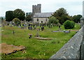
SE edge of St Dingat's churchyard, Llandovery
A view from the A4069 looking towards the Parish Church of St Dingat. http://www.geograph.org.uk/photo/3158337
Image: © Jaggery
Taken: 5 Jun 2011
0.05 miles
9
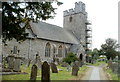
Llandovery: St Dingat's Church viewed from the SE
The Church in Wales parish church dates from 13th century with later modifications. St. Dingat was one of the sons of Brychan, a 6th century saint and chieftain of Irish origin. Brychan begat 36 children, many of whom also became Celtic saints.
Image: © Jaggery
Taken: 5 Jun 2011
0.05 miles
10
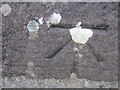
Ordnance Survey Cut Mark & Bolt
This OS cut mark can be found on the NW angle of St Dingat's Church tower. It marks a point 65.944m above mean sea level.
Image: © Adrian Dust
Taken: 1 Sep 2013
0.06 miles