IMAGES TAKEN NEAR TO
Llanddeusant, LLANGADOG, SA19 9YL
Introduction
This page details the photographs taken nearby to SA19 9YL by members of the Geograph project.
The Geograph project started in 2005 with the aim of publishing, organising and preserving representative images for every square kilometre of Great Britain, Ireland and the Isle of Man.

There are currently over 7.5m images from over14,400 individuals and you can help contribute to the project by visiting https://www.geograph.org.uk
Image Map
Images are licensed for reuse under creativecommons.org/licenses/by-sa/2.0
Notes
- Clicking on the map will re-center to the selected point.
- The higher the marker number, the further away the image location is from the centre of the postcode.
Image Listing (5 Images Found)
Images are licensed for reuse under creativecommons.org/licenses/by-sa/2.0
Image
Details
Distance
1
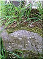
Ordnance Survey Rivet
This OS rivet can be found on the barn at Pant y Gwin Farm. It marks a point 272.732m above mean sea level.
Image: © Adrian Dust
Taken: 25 Jun 2020
0.01 miles
3
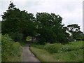
Ffarm Stangau Farm
Llwybr cyhoeddus yn arwain at Ffarm Stangau yn y pellter
A public footpath going in the direction of Stangau Farm in the distance
Image: © Alan Richards
Taken: 29 Nov 2013
0.17 miles
4
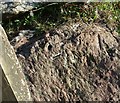
Ordnance Survey Rivet
This damaged OS rivet (arrow highlighted in chalk) can be found on the boulder at the field gateway. It marks a point 288.435m above mean sea level.
Image: © Adrian Dust
Taken: 25 Jun 2020
0.19 miles
5
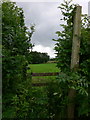
Footpath Stile & Post
Footpath from unclassified road.
Image: © Bonelli
Taken: Unknown
0.21 miles