IMAGES TAKEN NEAR TO
Llanddeusant, LLANGADOG, SA19 9UL
Introduction
This page details the photographs taken nearby to SA19 9UL by members of the Geograph project.
The Geograph project started in 2005 with the aim of publishing, organising and preserving representative images for every square kilometre of Great Britain, Ireland and the Isle of Man.

There are currently over 7.5m images from over14,400 individuals and you can help contribute to the project by visiting https://www.geograph.org.uk
Image Map
Images are licensed for reuse under creativecommons.org/licenses/by-sa/2.0
Notes
- Clicking on the map will re-center to the selected point.
- The higher the marker number, the further away the image location is from the centre of the postcode.
Image Listing (14 Images Found)
Images are licensed for reuse under creativecommons.org/licenses/by-sa/2.0
Image
Details
Distance
1
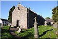
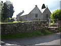
Llanddeusant church
The parish of Llanddeusant is a scattered community to the north of the Black Mountain. The name means Church of Two Saints and is so called because it is thought St Teilo and St David met in the village. Despite this the church is dedicated to St Simon and St Jude.
Image: © Philip Halling
Taken: 12 May 2012
0.02 miles
3
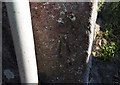
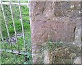
Ordnance Survey Cut Mark
This OS cut mark can be found on the SE angle of St Simon & St Jude's Church. It marks a point 266.615m above mean sea level.
Image: © Adrian Dust
Taken: 25 Jun 2020
0.02 miles
4
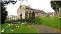
Llanddeusant church
Taken on an evening in June following a light rain shower.
Image: © Jeremy Bolwell
Taken: 11 Jun 2011
0.03 miles
5
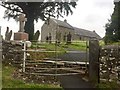
St Michael?s Church, Llanddeusant
Gateway to St Michael’s Church.
Image: © Alan Hughes
Taken: 4 Aug 2019
0.03 miles
6
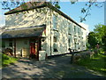
Llanddeusant Youth Hostel
The building was a former inn, The Red Lion, built in 1789. The red kite feeding station at Talsarn is one mile away.
Image: © George Tod
Taken: 10 Jun 2005
0.03 miles
7
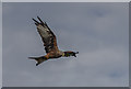
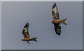
Red Kite at Red Kite Feeding Area, Llanddeusant
Image: © Christine Matthews
Taken: 4 Sep 2013
0.04 miles
8
Red Kite at Red Kites Feeding Area, Llanddeusant
Image: © Christine Matthews
Taken: 4 Sep 2013
0.04 miles
9
Ordnance Survey Cut Mark
This OS cut mark can be found on the wall of the cemetery. It marks a point 263.164m above mean sea level.
Image: © Adrian Dust
Taken: 25 Jun 2020
0.05 miles