IMAGES TAKEN NEAR TO
Llanddeusant, LLANGADOG, SA19 9TP
Introduction
This page details the photographs taken nearby to SA19 9TP by members of the Geograph project.
The Geograph project started in 2005 with the aim of publishing, organising and preserving representative images for every square kilometre of Great Britain, Ireland and the Isle of Man.

There are currently over 7.5m images from over14,400 individuals and you can help contribute to the project by visiting https://www.geograph.org.uk
Image Map
Images are licensed for reuse under creativecommons.org/licenses/by-sa/2.0
Notes
- Clicking on the map will re-center to the selected point.
- The higher the marker number, the further away the image location is from the centre of the postcode.
Image Listing (7 Images Found)
Images are licensed for reuse under creativecommons.org/licenses/by-sa/2.0
Image
Details
Distance
1
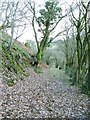
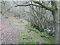
Footpath towards Wenallt
Instead of taking the farm road that ascends sharply to the left you can walk closer to the river this way on a public footpath.
Image: © Nigel Davies
Taken: 1 Mar 2009
0.02 miles
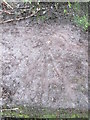
2
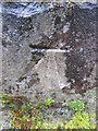
Ordnance Survey Cut Mark
This OS cut mark can be found on the roadside wall adjacent to the bridge. It marks a point 144.887m above mean sea level.
Image: © Adrian Dust
Taken: 26 Feb 2015
0.07 miles
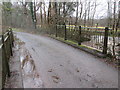
3
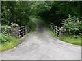
Bridge Over Afon Sawdde
Marked on OS 1:25000 as Cwm Du
Image: © Bonelli
Taken: Unknown
0.08 miles
4
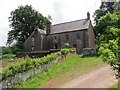
Ffarm Llwynfron Farm
Yn 1609 cofnodwyd taw Llwynfron oedd cartref teulu'r Aubrery. Mae'n debyg taw yr adeilad ar y chwith yw rhan hynaf o'r anhedd-dy presennol.
It is recorded that in 1609 Llwynfron (trans. hillside grove) was the family home of the Aubery's. The earliest surviving part of the property seems to be the adjoining building on the left.
Image: © Alan Richards
Taken: 5 Jul 2013
0.11 miles
5
Beside the Sawdde
This is a dead end, not the route of Image
The real footpath climbed the hill to the left of shot a while back.
Image: © Nigel Davies
Taken: 1 Mar 2009
0.19 miles
6
Bridge over Afon Llechach
There is an OS rivet on the west parapet. http://www.geograph.org.uk/photo/4362870
Image: © Adrian Dust
Taken: 26 Feb 2015
0.22 miles
7
Ordnance Survey Rivet
This OS rivet can be found on the west parapet of the bridge. It marks a point 141.162m above mean sea level. http://www.geograph.org.uk/photo/4362872
Image: © Adrian Dust
Taken: 26 Feb 2015
0.22 miles