IMAGES TAKEN NEAR TO
Gwynfe, LLANGADOG, SA19 9RU
Introduction
This page details the photographs taken nearby to SA19 9RU by members of the Geograph project.
The Geograph project started in 2005 with the aim of publishing, organising and preserving representative images for every square kilometre of Great Britain, Ireland and the Isle of Man.

There are currently over 7.5m images from over14,400 individuals and you can help contribute to the project by visiting https://www.geograph.org.uk
Image Map
Images are licensed for reuse under creativecommons.org/licenses/by-sa/2.0
Notes
- Clicking on the map will re-center to the selected point.
- The higher the marker number, the further away the image location is from the centre of the postcode.
Image Listing (8 Images Found)
Images are licensed for reuse under creativecommons.org/licenses/by-sa/2.0
Image
Details
Distance
1
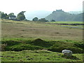
Farmhouse on Banc Wernwgan
The backdrop for this lonely farmhouse is the spectacular Carreg Cennen Castle (roughly due West).
Image: © Anthony Stevenson
Taken: 21 Sep 2003
0.00 miles
2
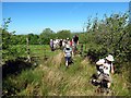
Llwybr Mount Pleasant Path
Cerddwyr yn dilyn llwybr cyhoeddus ger anhedd-dy o'r enw Mount Pleasant.
Walkers following a public footpath near a property called Mount Pleasant.
Image: © Alan Richards
Taken: 9 Jun 2013
0.05 miles
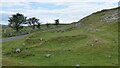
3
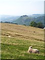
Ewe with a view
Sheep on the open moorside, and a view across to Carreg Cennen Castle.
Image: © Gordon Hatton
Taken: 4 Sep 2014
0.11 miles
4
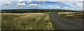
Mountain road
The mountain road from Ammanford to Capel Gwynfe cuts a swathe through the grass uplands of the Black Mountains.
Image: © Alan Hughes
Taken: 24 Aug 2017
0.16 miles
5
Gweddillion Pen y Pal / Remains of Pen y Pal
Dyma weddillion Ffarm Pen y Pal, cartref yn 1839 i Thomas Lewis a'i deulu. Yn anffodus yn ystod Mis Ebrill y flwyddyn honno cafwyd ei fab David Lewis, 5 oed, yn farw'n gelain ar y Mynydd Du ar ol iddo fynd ar goll tra’n chwilio am ei dad a weithiai yn un o gwarau’r mynydd ac o bosib ger yr enwog Tro'r Gwcw. Pan glywyd bod David ar goll bu chwilio ddyfal amdano am sawl diwrnod hyd nes y daethpwyd o hyd iddo ar y mynydd llwm yn gorwedd ar y ddaear rhwng dwy garreg, ei ben ar ei ancysher a osodwyd i lawr yn ofalus a'i ffon fach wrth ei ochr. Fe'i cludwyd i lawr y mynydd ac fe'i claddwyd ym mynwent Eglwys Llandeilo ar 12 Ebrill 1839.
The remains of Pen y Pal Farm (trans. top of the palisade), home in 1839 to Thomas Lewis and his family. During April of that year tragedy struck when his five-year-old son David perished on the nearby mountain. Thomas worked at one of the stone quarries on Mynydd Du (trans. Black Mountain) and possibly near the famous bend known as Tro'r Gwcw (trans. cuckoo bend) and on one particular day David decided to follow his father to his place of work but unfortunately got lost on the way. When the alarm was raised scores of people ventured onto the mountain to look for the young boy but without success. After being missing for three or four days David's body was eventually found lying on the ground between two rocks, his head resting on a carefully placed handkerchief with his little stick by his side. David was carried down the mountain and buried at St Teilo's burial ground, Llandeilo.
Image: © Alan Richards
Taken: 12 Apr 2021
0.19 miles
6
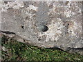
Ordnance Survey Rivet
This Ordnance Survey Rivet can be found on a small rock to the N of the road. At a junction of fences. It marks a point 317.7952m above mean sea level.
Image: © Adrian Dust
Taken: 8 Jun 2013
0.22 miles
7
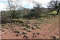
Enclosure and small rectangular earthwork building
A small road-side house and garden.
Image: © Sandy Gerrard
Taken: 29 Jun 2014
0.25 miles
8
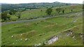
Enclosure and small rectangular earthwork building
A small road-side house and garden. View the hillside above.
Image: © Sandy Gerrard
Taken: 29 Jun 2014
0.25 miles