IMAGES TAKEN NEAR TO
Gwynfe, LLANGADOG, SA19 9RP
Introduction
This page details the photographs taken nearby to SA19 9RP by members of the Geograph project.
The Geograph project started in 2005 with the aim of publishing, organising and preserving representative images for every square kilometre of Great Britain, Ireland and the Isle of Man.

There are currently over 7.5m images from over14,400 individuals and you can help contribute to the project by visiting https://www.geograph.org.uk
Image Map
Images are licensed for reuse under creativecommons.org/licenses/by-sa/2.0
Notes
- Clicking on the map will re-center to the selected point.
- The higher the marker number, the further away the image location is from the centre of the postcode.
Image Listing (4 Images Found)
Images are licensed for reuse under creativecommons.org/licenses/by-sa/2.0
Image
Details
Distance
1
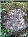
Ordnance Survey Rivet
This OS Rivet, with arrow, can be found on the west parapet of the bridge. It marks a point 209.9061m above mean sea level. http://www.geograph.org.uk/photo/3579157
Image: © Adrian Dust
Taken: 1 Aug 2013
0.04 miles
2
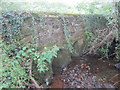
Bridge over stream
This bridge has an OS rivet on the west parapet. http://www.geograph.org.uk/photo/3579123
Image: © Adrian Dust
Taken: 1 Aug 2013
0.04 miles
3
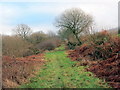
Llwybr ceffyl Cwm Ffrwd / Cwm Ffrwd bridleway
Llwybr ceffyl ger gweddillion Ffarm Cwm Ffrwd.
A bridleway near the remains of Cwm Ffrwd Farm (trans. stream valley).
Image: © Alan Richards
Taken: 19 Jan 2019
0.15 miles
4
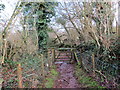
Llwybr ceffyl Cwm Ffrwd / Cwm Ffrwd bridleway
Llwybr ceffyl yn agosau at weddillion Ffarm Cwm Ffrwd.
A bridleway approaching the remains of Cwm Ffrwd Farm (trans. stream valley).
Image: © Alan Richards
Taken: 19 Jan 2019
0.24 miles