IMAGES TAKEN NEAR TO
Gwynfe, LLANGADOG, SA19 9RF
Introduction
This page details the photographs taken nearby to SA19 9RF by members of the Geograph project.
The Geograph project started in 2005 with the aim of publishing, organising and preserving representative images for every square kilometre of Great Britain, Ireland and the Isle of Man.

There are currently over 7.5m images from over14,400 individuals and you can help contribute to the project by visiting https://www.geograph.org.uk
Image Map
Images are licensed for reuse under creativecommons.org/licenses/by-sa/2.0
Notes
- Clicking on the map will re-center to the selected point.
- The higher the marker number, the further away the image location is from the centre of the postcode.
Image Listing (3 Images Found)
Images are licensed for reuse under creativecommons.org/licenses/by-sa/2.0
Image
Details
Distance
1
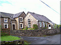
Old school and house
The school is now a dwelling, but it is ironic that the number of children in the area is greater now than it was at the time of closure a few years ago.
Image: © Jonathan Wilkins
Taken: 24 Jul 2007
0.02 miles
2
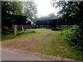
Farmyard at Bryncoch
Entrance to farmyard at Bryncoch.
Image: © Alan Hughes
Taken: 4 Aug 2019
0.10 miles