IMAGES TAKEN NEAR TO
Gwynfe, LLANGADOG, SA19 9PS
Introduction
This page details the photographs taken nearby to SA19 9PS by members of the Geograph project.
The Geograph project started in 2005 with the aim of publishing, organising and preserving representative images for every square kilometre of Great Britain, Ireland and the Isle of Man.

There are currently over 7.5m images from over14,400 individuals and you can help contribute to the project by visiting https://www.geograph.org.uk
Image Map (Loading...)


Getting Data...Please wait
Leaflet Map data © OpenStreetMap
Images are licensed for reuse under creativecommons.org/licenses/by-sa/2.0
Notes
- Clicking on the map will re-center to the selected point.
- The higher the marker number, the further away the image location is from the centre of the postcode.
Image Listing (6 Images Found)
Images are licensed for reuse under creativecommons.org/licenses/by-sa/2.0
Image
Details
Distance
1
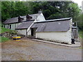
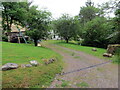
Pen Arthur Uchaf
Cyn Ffarm Pen Arthur Uchaf sy bellach yn ganolfan weithgareddau.
The former Pen Arthur Uchaf Farm (trans. upper farm of Arthur's summit / head) is nowadays an activity centre.
Image: © Alan Richards
Taken: 14 Jun 2021
0.01 miles
2
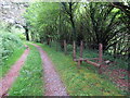
Llwybr Pen Arthur / Pen Arthur path
Ar y dde mae llwybr cyhoeddus yn gadael y trac ac yn mynd i gyfeiriad anhedd-dy o'r enw Pen Arthur sy bellach yn ganolfan weithgareddau.
On the right, a public footpath exits the track and heads in the direction of a property known as Pen Arthur (trans. Arthur's summit /head). The former farm is today an activity centre.
Image: © Alan Richards
Taken: 14 Jun 2021
0.06 miles
3
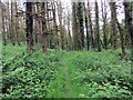
Llwybr Ysgubor-lan / Ysgubor-lan path
Llwybr cyhoeddus o fewn planhigfa goniferaidd ger anhedd-dy adfeiliedig Ysgubor-lan.
A public footpath within a conifer plantation near a ruinous property known as Ysgubor-lan (trans. upland barn).
Image: © Alan Richards
Taken: 14 Jun 2021
0.06 miles
4
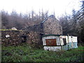
Ysgubor Lan
Adfeilion Ffarm Ysgubor Lan sy bellach wedi'i hamgylchynu gan blanhigfa goniferaidd.
The remains of Ysgubor Lan Farm (trans. hill barn) surrounded today by a conifer plantation.
Image: © Alan Richards
Taken: 3 Dec 2006
0.08 miles
5
Ffarm y Llety / Llety Farm
Llwybr yn mynd heibio i anhedd-dy o'r enw Llety (Llety Blaenystlysau gynt).
A path passing a property known as Llety (trans. abode) but formerly known as Llety Blaenystlysau (trans. abode at the head of the slopes).
Image: © Alan Richards
Taken: 14 Jun 2021
0.23 miles
6
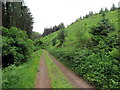
Trac y goedwigaeth / Forestry track
Hen heol ddiwyneb ger Pen Arthur.
An old unsurfaced road near Pen Arthur (trans. Arthur's summit / head).
Image: © Alan Richards
Taken: 14 Jun 2021
0.23 miles