IMAGES TAKEN NEAR TO
LLANGADOG, SA19 9NF
Introduction
This page details the photographs taken nearby to SA19 9NF by members of the Geograph project.
The Geograph project started in 2005 with the aim of publishing, organising and preserving representative images for every square kilometre of Great Britain, Ireland and the Isle of Man.

There are currently over 7.5m images from over14,400 individuals and you can help contribute to the project by visiting https://www.geograph.org.uk
Image Map (Loading...)


Getting Data...Please wait
Leaflet Map data © OpenStreetMap
Images are licensed for reuse under creativecommons.org/licenses/by-sa/2.0
Notes
- Clicking on the map will re-center to the selected point.
- The higher the marker number, the further away the image location is from the centre of the postcode.
Image Listing (3 Images Found)
Images are licensed for reuse under creativecommons.org/licenses/by-sa/2.0
Image
Details
Distance
1
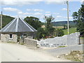
Octagonal building at Rosehill
An on-going building project and an attractively designed structure by the roadside half a mile west of Ashfield.
Image: © Jonathan Billinger
Taken: 9 Aug 2007
0.03 miles
2
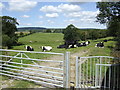
Footpath past the dairy cattle
Taken just six days into the Foot and Mouth outbreak in Surrey, these welsh beasts seem unconcerned that they are completely accessible by the public. I haven't been near Surrey this week!
Image: © Jonathan Billinger
Taken: 9 Aug 2007
0.05 miles
3
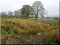
Felled Woodland
This area of woodland has been clear felled and you can see the trash of discarded branches on the ground among the rushes and rough herbage. Beyond you can see a field with sheep grazing. This unimproved ground could be returned to similar productive pasture if the owner thought it economically worthwhile to do so.
Image: © Marion Phillips
Taken: 25 Apr 2008
0.21 miles